IMAGES TAKEN NEAR TO
Helen Street, CRUMLIN, BT29 4XT
Introduction
This page details the photographs taken nearby to Helen Street, BT29 4XT by members of the Geograph project.
The Geograph project started in 2005 with the aim of publishing, organising and preserving representative images for every square kilometre of Great Britain, Ireland and the Isle of Man.

There are currently over 7.5m images from over14,400 individuals and you can help contribute to the project by visiting https://www.geograph.org.uk
Image Map
Images are licensed for reuse under creativecommons.org/licenses/by-sa/2.0
Notes
- Clicking on the map will re-center to the selected point.
- The higher the marker number, the further away the image location is from the centre of the postcode.
Image Listing (120 Images Found)
Images are licensed for reuse under creativecommons.org/licenses/by-sa/2.0
Image
Details
Distance
1
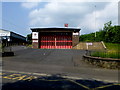
Fire station, Crumlin
Pictured along Mill Road
Image: © Kenneth Allen
Taken: 6 Jun 2016
0.05 miles
2
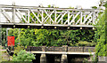
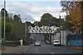
Railway viaduct, Crumlin (1)
The eastern side of a bridge (built by Alexander Findlay & Co Ltd, Motherwell in 1915) carrying the Lisburn – Antrim (right) railway across the Mill Road. A listed structure – the full description is available here http://www.doeni.gov.uk/niea/built/buildview?id=10798&js=true. Last seen in Image (December 2005). Not to be confused with this one Image Image shows the underside.
Image: © Albert Bridge
Taken: 17 Jun 2012
0.05 miles
3
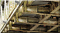
Railway viaduct, Crumlin (2)
See Image The view, underneath the bridge, showing the magnificent array of rivets used in its construction. Riveting is now a lost art. This link http://mysite.du.edu/~jcalvert/tech/rivets.htm discusses the pros and cons riveting and welding. Image shows the reinforcing on the northern parapet.
Image: © Albert Bridge
Taken: 17 Jun 2012
0.05 miles
4
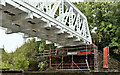
Railway viaduct, Crumlin (September 2017)
Crumlin viaduct - re-painted since this shot Image three years ago.
Image: © Albert Bridge
Taken: 16 Sep 2017
0.05 miles
6
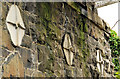
Railway viaduct, Crumlin (3)
See Image Reinforcing (no maker’s name visible) on the northern parapet. Added (to the best of my knowledge), in the early 1970’s, in preparation for the line’s re-opening to passenger trains.
Image: © Albert Bridge
Taken: 17 Jun 2012
0.06 miles
7
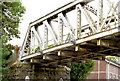
Railway viaduct, Crumlin (August 2014)
The western side of the viaduct http://www.geograph.org.uk/search.php?i=50634054, across the Mill Road, looking towards Antrim. I don’t know what’s happened at track level but this street-level view shows that it could do with a lick of paint.
Image: © Albert Bridge
Taken: 16 Aug 2014
0.06 miles
8
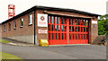
Fire station, Crumlin
A small station, on the Mill Road, with a crew of retained firefighters.
Image: © Albert Bridge
Taken: 17 Jun 2012
0.06 miles
9
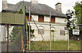
Former police station, Crumlin
The closed police station on the Mill Road. One of a series built, to a standard design (which included living accommodation) by TPO Rippingham, the Chief Architect at the Ministry of Finance, in the 1920’s/30’s. Many were closed and sold in the 1960’s. Some such examples may be found at Loughbrickland, Poyntzpass, Dundrum and Seaforde. Image shows a similar one in Templepatrick. Continue to Image
Image: © Albert Bridge
Taken: 17 Jun 2012
0.07 miles
10
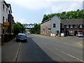
A32 Mill Road, Crumlin
Heading south-west
Image: © Kenneth Allen
Taken: 6 Jun 2016
0.07 miles