IMAGES TAKEN NEAR TO
Ravernet Road, LISBURN, BT27 5NH
Introduction
This page details the photographs taken nearby to Ravernet Road, BT27 5NH by members of the Geograph project.
The Geograph project started in 2005 with the aim of publishing, organising and preserving representative images for every square kilometre of Great Britain, Ireland and the Isle of Man.

There are currently over 7.5m images from over14,400 individuals and you can help contribute to the project by visiting https://www.geograph.org.uk
Image Map
Images are licensed for reuse under creativecommons.org/licenses/by-sa/2.0
Notes
- Clicking on the map will re-center to the selected point.
- The higher the marker number, the further away the image location is from the centre of the postcode.
Image Listing (11 Images Found)
Images are licensed for reuse under creativecommons.org/licenses/by-sa/2.0
Image
Details
Distance
1
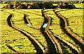
Rutted field near Ravernet
Beside the Ravarnet Road Image and apparently caused by a digger – reason unknown though.
Image: © Albert Bridge
Taken: 2 Feb 2009
0.09 miles
2
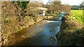
The Ravarnet River near Ravernet
The view downstream from the bridge on the Ravernet Road. The white building in the background is a gauging station used to monitor the state of the river and collect statistics on it.
Image: © Albert Bridge
Taken: 2 Feb 2009
0.11 miles
3
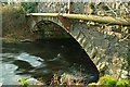
Bridge near Ravernet
Image: © Albert Bridge
Taken: 2 Feb 2009
0.12 miles
4
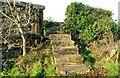
Steps near Ravernet
Image: © Albert Bridge
Taken: 2 Feb 2009
0.12 miles
5
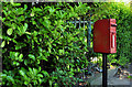
Letter box, Ravarnet near Lisburn
Post-mounted EIIR letter box on the Legacurry Road.
Image: © Albert Bridge
Taken: 3 Jul 2011
0.12 miles
6
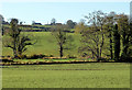
Fields and trees, Lisburn/Ravernet
Flat fields giving way to minor drumlins, on the south western side of the Ravarnet Road Image
Image: © Albert Bridge
Taken: 11 Nov 2012
0.14 miles
7
Hawthorn blossom, Ravernet near Lisburn
Hawthorn blossom off the Legacurry Road.
Image: © Albert Bridge
Taken: 27 May 2012
0.19 miles
8
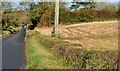
The Ravarnet Road near Lisburn
A mainly straight road running from the Hillsborough Road Image to Ravernet village. Note the use of different spellings for the road and the village.
Image: © Albert Bridge
Taken: 11 Nov 2012
0.22 miles
9
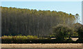
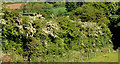
Trees, Taghnabrick near Lisburn (2)
The southern side of one of two plantations in an area not generally noted for woodland. Image (May 2012) shows the plantation from a completely different viewpoint. This view is from the Ravarnet Road Image
Image: © Albert Bridge
Taken: 11 Nov 2012
0.22 miles
10
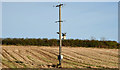
Pole and power lines, Lisburn/Ravernet
A pole, carrying power lines across a field, on the eastern side of the Ravarnet Road Image
Image: © Albert Bridge
Taken: 11 Nov 2012
0.22 miles