IMAGES TAKEN NEAR TO
Glenmore Manor, LISBURN, BT27 4BZ
Introduction
This page details the photographs taken nearby to Glenmore Manor, BT27 4BZ by members of the Geograph project.
The Geograph project started in 2005 with the aim of publishing, organising and preserving representative images for every square kilometre of Great Britain, Ireland and the Isle of Man.

There are currently over 7.5m images from over14,400 individuals and you can help contribute to the project by visiting https://www.geograph.org.uk
Image Map
Images are licensed for reuse under creativecommons.org/licenses/by-sa/2.0
Notes
- Clicking on the map will re-center to the selected point.
- The higher the marker number, the further away the image location is from the centre of the postcode.
Image Listing (111 Images Found)
Images are licensed for reuse under creativecommons.org/licenses/by-sa/2.0
Image
Details
Distance
1

Former Lambeg post office
The post office when it was on the Lambeg Road. The present one is in a Spar at Queensway - see Image
Image: © Albert Bridge
Taken: 14 Aug 1983
0.03 miles
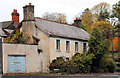
2
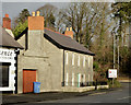
Restored house, Lambeg
See Image (November 2010). The same house after restoration.
Image: © Albert Bridge
Taken: 2 Jan 2014
0.03 miles
3
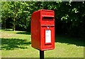
Letter box, Lambeg
ER box on the Lambeg Road close to the Station Road Image
Image: © Albert Bridge
Taken: 24 Jun 2009
0.04 miles
4
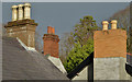
Chimneys, Lambeg
A selection of chimneys and pots, on the Lambeg Road, opposite the Tullynacross Road. It looks as if all three buildings were built as houses but some were later converted for commercial use.
Image: © Albert Bridge
Taken: 2 Jan 2014
0.05 miles
5
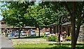
Priory Close, Lambeg
A cul-de-sac of small bungalows off the Lambeg Road.
Image: © Albert Bridge
Taken: 24 Jun 2009
0.06 miles
6
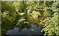
The River Lagan, Lambeg (July 2018)
This was supposed to be a shot of the low Lagan and the effects of the continuing dry spell. In fact the trees have grown so much, since this one Image (April 2010), that it’s no longer possible to see the banks. Looking upstream from the footbridge.
Image: © Albert Bridge
Taken: 7 Jul 2018
0.06 miles
7
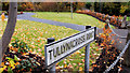
Tullynacross Road sign, Lambeg
The sign at the Lambeg Road end of the Tullynacross Road Image
Image: © Albert Bridge
Taken: 5 Nov 2010
0.06 miles
8
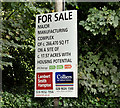
Former Coca-Cola factory, Lambeg (September 2016)
See Image The former premises have been on the market, for some time, following the move to new premises at Lissue. They are described as “The site provides for approximately 266,470 sq ft of industrial, storage and ancillary office buildings, together with canopied loading bays. The buildings comprise a mix of good quality warehousing with the more modern warehousing elements providing for excellent accommodation and a good eaves height of c.23’11”(c.7.3m). The former factory and warehouse accommodation interlink from front to rear.”
They are not visible from the public road. I have no connection with any of the parties involved in the sale.
Image: © Albert Bridge
Taken: 29 Sep 2016
0.06 miles
9
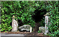
Disused gateway, Lambeg
A disused and overgrown gateway at the Lambeg Road end of Bell’s Lane. It was, I think, the entrance to Aberdelghy http://www.geograph.org.uk/snippet/5280 but now leads to Aberdelghy golf course Image During WWII the house was used as a billet for American soldiers.
Image: © Albert Bridge
Taken: 18 Jun 2011
0.06 miles
10
Vacant house, Lambeg
A long-vacant house, at the corner of the Lambeg Road and Bell’s Lane.Image shows a post-restoration view in January 2014.
Image: © Albert Bridge
Taken: 5 Nov 2010
0.07 miles