IMAGES TAKEN NEAR TO
Scholars Court, DROMORE, BT25 1FT
Introduction
This page details the photographs taken nearby to Scholars Court, BT25 1FT by members of the Geograph project.
The Geograph project started in 2005 with the aim of publishing, organising and preserving representative images for every square kilometre of Great Britain, Ireland and the Isle of Man.

There are currently over 7.5m images from over14,400 individuals and you can help contribute to the project by visiting https://www.geograph.org.uk
Image Map
Images are licensed for reuse under creativecommons.org/licenses/by-sa/2.0
Notes
- Clicking on the map will re-center to the selected point.
- The higher the marker number, the further away the image location is from the centre of the postcode.
Image Listing (276 Images Found)
Images are licensed for reuse under creativecommons.org/licenses/by-sa/2.0
Image
Details
Distance
1
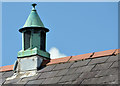
Lantern, Dromore
One of two lanterns of the roof of Banbridge Road Presbyterian church Image hall.
Image: © Albert Bridge
Taken: 27 Jul 2013
0.03 miles
2
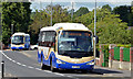
Two Goldline coaches, Dromore (2013-1)
Two Ulsterbus Irizar-bodied Scanias on the Banbridge Road. The first (1043 JFZ 9043) is working the 10.15 Newry – Belfast Goldline express. The second (1008 JFZ 7008) is an empty relief which, in the event, was not needed. See also Image
Image: © Albert Bridge
Taken: 27 Jul 2013
0.03 miles
3
Avenue leading to Skeagh House
This nameless stretch of tarmac links the Banbridge Road with Skeagh House and more recently Bishopshill (the entrance to which can be seen to the right). Skeagh House is a residential care home.
Image: © Dean Molyneaux
Taken: 20 Jul 2009
0.04 miles
5
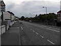
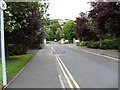
Banbridge Road, Dromore
The Banbridge Road in Dromore - known locally as the 'Bann Road'.
Image: © Dean Molyneaux
Taken: 14 Jul 2009
0.04 miles
6

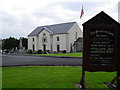
Banbridge Road Presbyterian Church and Sabbath Schoolroom, Dromore
These are located at the junction of Banbridge Road and Castle Street.
Image: © Eric Jones
Taken: 4 Apr 2017
0.04 miles
7
First Presbyterian Church (Non-Subscribing), Dromore
Located on Barban Hill, at the point where the old coach road once broke off. The congregation was formed in 1660 and after some tumultuous centuries - and a schism from mainstream Presbyterianism - this church building was built in 1800.
Image: © Dean Molyneaux
Taken: 14 Jul 2009
0.05 miles
8
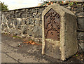
Milestone, Dromore
A milestone, on the Banbridge Road, showing the distances in Irish miles. The road was once part of a turnpike and also on the route used by the Belfast – Dublin mail coaches. There is also a cut bench mark on the bottom of the milestone, levelled to 74.02 metres above MSL.
Image: © Albert Bridge
Taken: 23 Sep 2011
0.06 miles
9
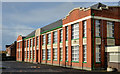
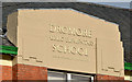
Dromore Central primary school (1)
Dromore Central primary school on the Banbridge Road. Built in 1938 as Dromore public elementary school replacing (to the best of my knowledge) former Church of Ireland and Unitarian schools. The design is typical of the era and is similar to the Abercorn in Banbridge. It sits in two squares. Taken during the mid-term break. Image shows the inscription on the front of the building.
Image: © Albert Bridge
Taken: 2 Nov 2012
0.06 miles
10
Dromore Central primary school (2)
See Image The inscription on the front of the building.
Image: © Albert Bridge
Taken: 2 Nov 2012
0.06 miles