IMAGES TAKEN NEAR TO
Victoria Gardens, NEWTOWNARDS, BT22 1BN
Introduction
This page details the photographs taken nearby to Victoria Gardens, BT22 1BN by members of the Geograph project.
The Geograph project started in 2005 with the aim of publishing, organising and preserving representative images for every square kilometre of Great Britain, Ireland and the Isle of Man.

There are currently over 7.5m images from over14,400 individuals and you can help contribute to the project by visiting https://www.geograph.org.uk
Image Map
Images are licensed for reuse under creativecommons.org/licenses/by-sa/2.0
Notes
- Clicking on the map will re-center to the selected point.
- The higher the marker number, the further away the image location is from the centre of the postcode.
Image Listing (19 Images Found)
Images are licensed for reuse under creativecommons.org/licenses/by-sa/2.0
Image
Details
Distance
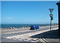
1
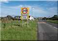
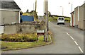
Entering Ballyhalbert
Arriving at the village of Ballyhalbert from Victoria Road.
Image: © Rossographer
Taken: 3 Sep 2023
0.11 miles
2
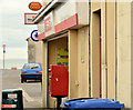
Letter box, Ballyhalbert
Post-mounted EIIR letter box (BT22 647) at the post office, High Street.
Image: © Albert Bridge
Taken: 27 Sep 2012
0.13 miles
3
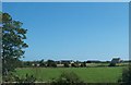
Rural settlement south of Victoria Road, Ballyhalbert
Image: © Eric Jones
Taken: 2 Aug 2013
0.13 miles
4
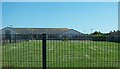
Victoria Primary School, Ballyhalbert
The school is situated in Victoria Street.
Image: © Eric Jones
Taken: 2 Aug 2013
0.16 miles
5
The Moat Road, Ballyhalbert
The Moat Road is a minor road running from the Shore Road/Portavogie Road towards Ballyeasborough Image Once known as the Tounheid.
Image: © Albert Bridge
Taken: 27 Sep 2012
0.18 miles
6
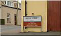
"High Street" sign, Ballyhalbert
A sign, at the Shore Road end of High Street, recalling two place names – the Kye Watter and Auchtrie’s Wal - which have long-since vanished into history.
Image: © Albert Bridge
Taken: 27 Sep 2012
0.18 miles
7
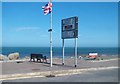
Direction sign at the junction of Harbour Road and High Street, Ballyhalbert
Ballyhalbert has a population of just under 500.
Image: © Eric Jones
Taken: 2 Aug 2013
0.18 miles
8
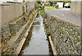
The Clydesburn, Ballyhalbert (1)
I might be wrong but (I think) the Clydesburn was a race/lade/carry which once powered a corn mill. This view is from the Shore Road Image just before the water flows into the Irish Sea. Image shows it entering the sea.
Image: © Albert Bridge
Taken: 27 Sep 2012
0.18 miles
10
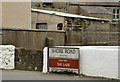
"Shore Road" sign, Ballyhalbert
The sign recalling the Shore Road’s original name “The Lade” Image
Image: © Albert Bridge
Taken: 27 Sep 2012
0.19 miles