IMAGES TAKEN NEAR TO
Shandon Drive, BANGOR, BT20 5HL
Introduction
This page details the photographs taken nearby to Shandon Drive, BT20 5HL by members of the Geograph project.
The Geograph project started in 2005 with the aim of publishing, organising and preserving representative images for every square kilometre of Great Britain, Ireland and the Isle of Man.

There are currently over 7.5m images from over14,400 individuals and you can help contribute to the project by visiting https://www.geograph.org.uk
Image Map
Images are licensed for reuse under creativecommons.org/licenses/by-sa/2.0
Notes
- Clicking on the map will re-center to the selected point.
- The higher the marker number, the further away the image location is from the centre of the postcode.
Image Listing (280 Images Found)
Images are licensed for reuse under creativecommons.org/licenses/by-sa/2.0
Image
Details
Distance
1
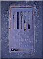
Grating, Bangor
An old grating that sits right in the middle of Shandon Drive in Bangor. Although badly worn, the inscription "Union Foundry Belfast" can still just be seen. Interestingly, Shandon Drive has recently been resurfaced and almost all the manhole and grating covers were removed and replaced - this was the only one left untouched, even though it appears to be blocked and serve no useful purpose.
Image: © Rossographer
Taken: 2 Apr 2011
0.02 miles
2
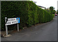
Shadon Park West, Bangor
Short cul-de-sac off Clifton Road. Laid out in the 1920s.
Image: © Rossographer
Taken: 9 Jul 2009
0.04 miles
3
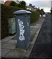
Old electricity box, Bangor
Another of the old electricity boxes found in Bangor. This one is on Shandon Drive. Again marked 'Borough of Bangor Electricity Department'. Made by Johnson & Phillips Electrical Engineers of London. See also http://www.geograph.org.uk/search.php?i=9637907 for some related images.
Image: © Rossographer
Taken: 12 Dec 2009
0.06 miles
4
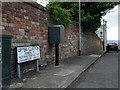
Upper Clifton, Bangor
Short street running off Clifton Road and leading, as the sign shows, to Carrisbrooke Image and Victoria Terrace Image
Image: © Rossographer
Taken: 9 Jul 2009
0.09 miles
5
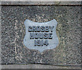
Demolition, Bangor
This part of the school will be retained and turned into apartments. The plaque reads 'Crosby House, 1914'.
Image: © Rossographer
Taken: 21 Apr 2013
0.10 miles
6
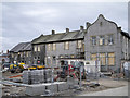
College Green redevelopment, Bangor
The former Crosby House, part of Bangor Grammar School Image, now apparently undergoing redevelopment into apartments.
Image: © Rossographer
Taken: 14 Apr 2015
0.10 miles
7
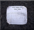
Demolition, Bangor
This was blowing about in the wind outside. Such cards will be familiar to thousands of past pupils who were issued with one at the start of each school year. The school day, beginning after assembly at 9:05am, was split into 8 periods of 40 minutes; break was between periods 3 & 4 from 11:05am-11:20am; lunch (50 minutes) was either period 6 or 7 depending what year you were in and the day finished at 3:20pm. Nowadays pupils are given a computer print-out of their classes.
Image: © Rossographer
Taken: 21 Apr 2013
0.10 miles
8
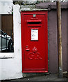
Postbox, Bangor
Wall mounted George V postbox on Victoria Road in Bangor (BT20 276).
The maker of this box was
McDowell, Steven & Co. Ltd, of London and Falkirk.
Image: © Rossographer
Taken: 22 Nov 2009
0.10 miles
9
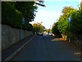
Ward Avenue
Looking towards the Seacliff Road. Unlike nearby Ballyholme Road Image, Ward Ave has not (yet) been touched by the dreaded developers.
Image: © Rossographer
Taken: 6 Oct 2007
0.11 miles
10
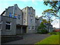
Bangor Grammar School
This is the oldest section of the school, dating from 1905. The rest of the school buildings (unseen, behind) have been built in stages over the last 100 years.
This building is known as the Crosby Building - in fact, only the far right hand portion, added in 1914, is officially known as Crosby House. The low section on the left was added in 1960.
This was taken in 2007 when the school was still sited here: the site was vacated at the end of 2012 when it relocated to a new campus on Gransha Road. The Crosby Building/Crosby House is retained, the other buildings demolished (see http://www.geograph.org.uk/snippet/8816 ).
Image: © Rossographer
Taken: 6 Oct 2007
0.11 miles