IMAGES TAKEN NEAR TO
College Avenue, BANGOR, BT20 5HJ
Introduction
This page details the photographs taken nearby to College Avenue, BT20 5HJ by members of the Geograph project.
The Geograph project started in 2005 with the aim of publishing, organising and preserving representative images for every square kilometre of Great Britain, Ireland and the Isle of Man.

There are currently over 7.5m images from over14,400 individuals and you can help contribute to the project by visiting https://www.geograph.org.uk
Image Map
Images are licensed for reuse under creativecommons.org/licenses/by-sa/2.0
Notes
- Clicking on the map will re-center to the selected point.
- The higher the marker number, the further away the image location is from the centre of the postcode.
Image Listing (211 Images Found)
Images are licensed for reuse under creativecommons.org/licenses/by-sa/2.0
Image
Details
Distance
1
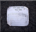
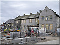
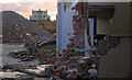
Demolition, Bangor
This was blowing about in the wind outside. Such cards will be familiar to thousands of past pupils who were issued with one at the start of each school year. The school day, beginning after assembly at 9:05am, was split into 8 periods of 40 minutes; break was between periods 3 & 4 from 11:05am-11:20am; lunch (50 minutes) was either period 6 or 7 depending what year you were in and the day finished at 3:20pm. Nowadays pupils are given a computer print-out of their classes.
Image: © Rossographer
Taken: 21 Apr 2013
0.03 miles
2
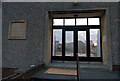
Demolition, Bangor
The former entrance to the assembly hall, or what remains of it.
Image: © Rossographer
Taken: 21 Apr 2013
0.03 miles
3
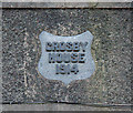
Demolition, Bangor
This part of the school will be retained and turned into apartments. The plaque reads 'Crosby House, 1914'.
Image: © Rossographer
Taken: 21 Apr 2013
0.04 miles
4
Demolition, Bangor
The school name, this was located on the front of the assembly hall. Below 'Bangor Grammar School' is written 'Founded 1856'.
Image: © Rossographer
Taken: 21 Apr 2013
0.04 miles
5
College Green redevelopment, Bangor
The former Crosby House, part of Bangor Grammar School Image, now apparently undergoing redevelopment into apartments.
Image: © Rossographer
Taken: 14 Apr 2015
0.04 miles
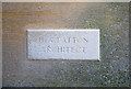
6
Demolition, Bangor
This little plaque was located outside the entrance to the assembly hall. The architect, H.A. Patton, was responsible for the extension which built c1960. There were further building works on the site up until c2000.
Image: © Rossographer
Taken: 21 Apr 2013
0.04 miles
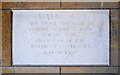
7
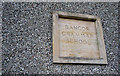
Demolition, Bangor
A plaque which was located outside the entrance to the assembly hall. It reads:
"This stone was laid by Samuel McKee Claney
Former pupil, chairman of the Board of Governors
March 1960".
It probably commemorates the building or opening of the extension built c1960.
Image: © Rossographer
Taken: 21 Apr 2013
0.04 miles
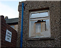
8
Demolition, Bangor
A smashed window in what remains of the assembly hall. The Crosby building behind will be retained.
Image: © Rossographer
Taken: 21 Apr 2013
0.04 miles
9
Demolition, Bangor
More of the demolition work - this was the north part of the assembly hall that connected to the Crosby building.
Image: © Rossographer
Taken: 21 Apr 2013
0.04 miles
10
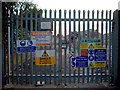
Demolition, Bangor
Gates and signs. Access is impossible during the demolition work.
Image: © Rossographer
Taken: 21 Apr 2013
0.05 miles