IMAGES TAKEN NEAR TO
Manselton Park, BANGOR, BT20 4LY
Introduction
This page details the photographs taken nearby to Manselton Park, BT20 4LY by members of the Geograph project.
The Geograph project started in 2005 with the aim of publishing, organising and preserving representative images for every square kilometre of Great Britain, Ireland and the Isle of Man.

There are currently over 7.5m images from over14,400 individuals and you can help contribute to the project by visiting https://www.geograph.org.uk
Image Map
Images are licensed for reuse under creativecommons.org/licenses/by-sa/2.0
Notes
- Clicking on the map will re-center to the selected point.
- The higher the marker number, the further away the image location is from the centre of the postcode.
Image Listing (35 Images Found)
Images are licensed for reuse under creativecommons.org/licenses/by-sa/2.0
Image
Details
Distance
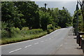
1
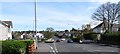
View east along Donaghadee Road, Bangor
The junction on the left is the one with Groomsport Road.
Image: © Eric Jones
Taken: 17 Apr 2017
0.07 miles
2
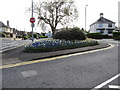
Flower beds at the junction of Groomsport Road and Donaghadee Road
Image: © Eric Jones
Taken: 17 Apr 2017
0.07 miles
3
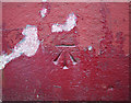
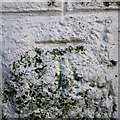
Bench Mark, Bangor
Cut bench mark on a gatepost on the Donaghadee Road in Bangor, very close to the corner of Mansleton Park.
The mark is 12.11 metres above MSL.
See also http://www.geograph.org.uk/search.php?i=11037856 for many other examples I have found.
Image: © Rossographer
Taken: 13 Mar 2010
0.08 miles
4
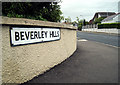
Beverley Hills, Bangor
One of several areas in Bangor named after famous American streets.
Beverley Hills was developed around the 1920s/1930s, coinciding with the American cinematic influences of the age. Marcus Patton http://www.worldcat.org/isbn/090045752X records that "the road was developed on the line of a lane that originally led to the farm of Samuel Johnson, whose wife Amy was a devotee of the silver screen".
Image: © Rossographer
Taken: 20 Jun 2009
0.08 miles
5
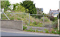
Development site, Bangor (2013-1)
A site, on the Donaghadee Road almost opposite Manselton Close, offered for sale. The agents’ description includes the following “The consent was granted in full on 29 March 2009 (Ref: W/2007/1073/F) . . . . . . The site has the benefit of full planning permission for some 9 No. units, comprising 4 No. apartments (2 bed / 1 rec); 2 No. No. semi-detached (3 bed / 3 rec) and 3 No. townhouses (3 bed / 3 rec)”. This photograph appears as a matter of record only. I have no connection with any of the parties involved in the sale.
Image: © Albert Bridge
Taken: 21 May 2013
0.08 miles
6
Bench Mark, Bangor
Cut bench mark located on a wall on the Groomsport Road in Bangor.
The mark is 8.64 metres above MSL.
Image: © Rossographer
Taken: 17 Apr 2012
0.10 miles
7
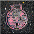
Air valve cover, Bangor
What appears to be an air valve cover on the Groomsport Road in Bangor. The cover is of a very similar size to Belfast Water Works covers such as Image
Image: © Rossographer
Taken: 17 Apr 2012
0.12 miles
8
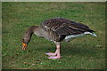
A "big duck" in Ward Park
If you ever visited Ward Park in Bangor as a toddler you might remember your first (frightening) encounter with the “big ducks”. In later years when you had read the “Observers Book of Birds” you discovered that the “big ducks” were really greylag geese. They are resident in the park. This one is having a late breakfast.
Image: © Albert Bridge
Taken: 13 Aug 2006
0.13 miles
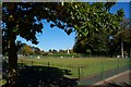
9
Broadway, Bangor
Broadway is a residential road very close to the centre of Bangor. It is also quite a busy road and a certain amount of patience was needed to find a gap in the traffic. The land behind the trees on the left is the golf course.
Image: © Albert Bridge
Taken: 21 Jun 2006
0.13 miles
10
Bowling green, Bangor (2007)
The bowling green in Ward Park. The war memorial Image is in the middle of the photo. For a later view see Image (November 2012).
Image: © Albert Bridge
Taken: 27 Sep 2007
0.13 miles