IMAGES TAKEN NEAR TO
Stricklands Bay, BANGOR, BT20 3RX

Introduction

This page details the photographs taken nearby to Stricklands Bay, BT20 3RX by members of the Geograph project.

The Geograph project started in 2005 with the aim of publishing, organising and preserving representative images for every square kilometre of Great Britain, Ireland and the Isle of Man.

There are currently over 7.5m images from over14,400 individuals and you can help contribute to the project by visiting https://www.geograph.org.uk

Image Map


Images are licensed for reuse under creativecommons.org/licenses/by-sa/2.0
Notes
  • Clicking on the map will re-center to the selected point.
  • The higher the marker number, the further away the image location is from the centre of the postcode.

Image Listing (65 Images Found)

Images are licensed for reuse under creativecommons.org/licenses/by-sa/2.0
  • ...
Image
Details
Distance
1
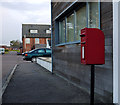
Postbox, Bangor
Post mounted Elizabeth II postbox (BT20 274) at Stricklands Care Village (Northern Ireland Institute for the Disabled) on the Downshire Road in Bangor.
Image: © Rossographer Taken: 20 Apr 2012
0.04 miles
2
Kensington Park, Bangor
Street of detached houses running between Downshire Road and Maxwell Road in Bangor. Laid out on the site of former clay pits c1930, the street was originally named 'Westward Ho!' but the current name was quickly adopted by 1935.
Image: © Rossographer Taken: 20 Apr 2012
0.05 miles
3
North Down Coastal Path near Smelt Mill Bay
Looking towards Bangor, the North Down Coastal Path at Smelt Mill Bay near Stricklands Glen.
Image: © Rossographer Taken: 16 Mar 2008
0.08 miles
4
Stricklands Glen
This is the entrance to Stricklands Glen as viewed from the North Down Coastal Path.
Image: © Rossographer Taken: 16 Jun 2007
0.09 miles
5
Sewerage works, Bangor
An upgrade to the sewerage pumping station at Stricklands Glen in Bangor which has now been going on for nearly a year - see Image from March 2020.
Image: © Rossographer Taken: 2 Mar 2021
0.10 miles
6
Lesser Celandine near Bangor
A single bloom of a small clump growing in undergrowth just off the North Down Coastal Path near Smelt Mill Bay.
Image: © Rossographer Taken: 27 Apr 2008
0.10 miles
7
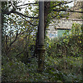
Sewage Vent Pipe, Bangor
A complete sewage vent pipe (stench pipe) located in trees at the coastal end of Stricklands Glen in Bangor (see Image for a wider angle view). The trees obscure the full height but it is similar to this example Image and probably unique in Bangor. The pipe was manufactured by Ham Baker & Co. of Westminster - this is the worn foundry inscription but it should look like this Image
Image: © Rossographer Taken: 4 Nov 2016
0.10 miles
8
Sewage Vent Pipe, Bangor
A complete sewage vent pipe (stench pipe) located in trees at the coastal end of Stricklands Glen in Bangor. The trees obscure the full height but it is similar to this example Image and probably unique in Bangor. The pipe was manufactured by Ham Baker & Co. of Westminster - see Image for the foundry inscription.
Image: © Rossographer Taken: 4 Nov 2016
0.10 miles
9
Thalassa
The house on the right is called Thalassa; it sits prominently just above the coastal path between Brompton and Smelt Mill Bay (Stricklands Glen). Currently under threat of demolition it has lain empty for many years - developers want to replace it with something like that on the left (which I actually like - I just wish they wouldn't knock down delightful period properties!).
Image: © Rossographer Taken: 7 Oct 2007
0.11 miles
10
Downshire Road, Bangor
Downshire Road runs from the Princetown Road to Stricklands Glen, bisected by the Maxwell Road as can be seen from this picture. It is a pleasant mature road of mainly large detached houses.
Image: © Rossographer Taken: 8 Jul 2008
0.11 miles
  • ...