IMAGES TAKEN NEAR TO
Maxwell Road, BANGOR, BT20 3RA
Introduction
This page details the photographs taken nearby to Maxwell Road, BT20 3RA by members of the Geograph project.
The Geograph project started in 2005 with the aim of publishing, organising and preserving representative images for every square kilometre of Great Britain, Ireland and the Isle of Man.

There are currently over 7.5m images from over14,400 individuals and you can help contribute to the project by visiting https://www.geograph.org.uk
Image Map
Images are licensed for reuse under creativecommons.org/licenses/by-sa/2.0
Notes
- Clicking on the map will re-center to the selected point.
- The higher the marker number, the further away the image location is from the centre of the postcode.
Image Listing (97 Images Found)
Images are licensed for reuse under creativecommons.org/licenses/by-sa/2.0
Image
Details
Distance
1
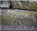
Bench Mark, Bangor
Cut bench mark at the foot of a wall in front of a house on the Maxwell Road in Bangor.
See also http://www.geograph.org.uk/search.php?i=11037856 for many other examples I have found.
Image: © Rossographer
Taken: 7 Mar 2010
0.04 miles
3
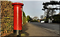
Pillar box, Bangor
See Image Possibly the same GR pillar box but on the Maxwell Road just past the corner of the Downshire Road.
Image: © Albert Bridge
Taken: 1 Dec 2011
0.09 miles
4
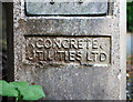
Lamppost, bangor
Detail of a lamppost located on Raglan Road in Bangor. A concrete post, it was made by "Concrete Utilities Ltd.". The company was established in the UK in 1923 by Charles Marques M.B.E., an Australian from Adelaide who came to Britain after fighting in the First World War. The company, still owned by the Marques family, continues to trade today but is known as "CU Phosco Lighting" http://www.cuphosco.com .
Image: © Rossographer
Taken: 20 Apr 2011
0.10 miles
5
![Old electricity box, Bangor [3]](https://s3.geograph.org.uk/photos/87/63/876335_f6cf3680_120x120.jpg)
Old electricity box, Bangor [3]
Another old electricity box of the same design and same crests as those seen in Image and Image (they are quite numerous in the Maxwell Road / Princetown Road / Downshire Road area of Bangor - I didn't bother photographing them all).
Image: © Rossographer
Taken: 8 Jul 2008
0.10 miles
6

Postbox, Bangor
George V pillar box on Maxwell Road in Bangor (BT20 548).
Image: © Rossographer
Taken: 8 Jul 2008
0.11 miles
7

Construction site, Bangor
Construction site at the shoreline by Brompton in Bangor. Three modern dwellings are being constructed, replacing one bungalow. The walkers in the foreground are on the North Down Coastal Path heading towards Bangor.
Image: © Rossographer
Taken: 29 Apr 2019
0.11 miles
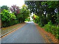
8

Brompton Road, Bangor
One end of Brompton Road, near the junction with Downshire Road. The road is a cul-de-sac and leads to the shore of Belfast Lough - see Image
Image: © Rossographer
Taken: 8 Jul 2008
0.12 miles
9
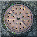
Manhole cover, Bangor
Manhole cover located on the North Down Coastal Path near Brompton Road in Bangor. No names or markings on this example, although it is clearly quite old.
Image: © Rossographer
Taken: 11 Jun 2011
0.13 miles
10
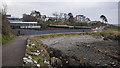
Path, Bangor
The North Down Coastal Path at Brompton, Bangor. The houses last seen in Image now look virtually complete. Taken during the Covid-19 pandemic, there were still a fair number of walkers out but most maintaining a distance from others.
Image: © Rossographer
Taken: 25 Mar 2020
0.13 miles