IMAGES TAKEN NEAR TO
Lancaster Avenue, BANGOR, BT20 3DB
Introduction
This page details the photographs taken nearby to Lancaster Avenue, BT20 3DB by members of the Geograph project.
The Geograph project started in 2005 with the aim of publishing, organising and preserving representative images for every square kilometre of Great Britain, Ireland and the Isle of Man.

There are currently over 7.5m images from over14,400 individuals and you can help contribute to the project by visiting https://www.geograph.org.uk
Image Map
Images are licensed for reuse under creativecommons.org/licenses/by-sa/2.0
Notes
- Clicking on the map will re-center to the selected point.
- The higher the marker number, the further away the image location is from the centre of the postcode.
Image Listing (237 Images Found)
Images are licensed for reuse under creativecommons.org/licenses/by-sa/2.0
Image
Details
Distance
1
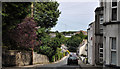
Windsor Park, Bangor
A narrow street, on the western side of the Manse Road (bottom) built, in the early 1930’s, on the site of what had once been allotments. The view is from Windsor Gardens Image
Image: © Albert Bridge
Taken: 1 Oct 2013
0.06 miles
2
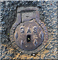
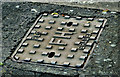
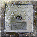
Old gas cover, Bangor
A small access cover marked 'Gas' located on Manse Road in Bangor. It almost certainly dates from when the town gas was produced and supplied in Bangor - this ended c1987.
The cover was cast by Hattersley and Davidson of Sheffield. This engineering company was established in 1894; the company still trades today as Hd Sports Ltd. http://www.hdsports.co.uk/hdsports-history.html but specialises in ice skating blades.
Image: © Rossographer
Taken: 2 May 2012
0.07 miles
3
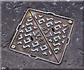
Brickhouse access cover, Bangor
A Brickhouse “Victor” access cover on a gas main at the Brunswick Road end of the Manse Road. This link http://www.geograph.org.uk/search.php?i=22301408 shows other products, on Geograph, from the same foundry.
Image: © Albert Bridge
Taken: 14 Jun 2011
0.08 miles
4
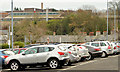
Car park, Dufferin Avenue, Bangor (1)
See Image Originally free and busy, the public car park at Dufferin Avenue (officially Dufferin Square) was converted to “pay and display” in 2013. Drivers seemed to shun it after introduction of the charge. It became free again – in the words of an official announcement (December 2013) “I am aware there is a significant, and growing, demand for Park and Ride facilities in Bangor and that the current Park and Ride site on Abbey Street is operating at capacity. I am also aware this growing demand has led to difficulties regarding parking around train halts along the railway line between Bangor and Belfast. I have subsequently concluded that the conversion of the existing Dufferin Avenue car park to a Park & Ride facility represents the best, and most immediate, solution.” See also Image The railway/bus station Image is at top left.
Image: © Albert Bridge
Taken: 5 Mar 2014
0.08 miles
5
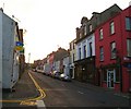
Railway View Street, Bangor
A steepish street, built over a period from circa 1875 to the early 20th century, dropping from the Manse Road to Dufferin Avenue (hidden to the left in the background). The railway station http://www.geograph.org.uk/search.php?i=22301863 is the bright spot in the trees towards the middle right.
Image: © Albert Bridge
Taken: 14 Jun 2011
0.08 miles
6
"PLC" fire hydrant cover, Bangor
See Image (April 2011). A similar product, without the “Vina” name, at the Bryansburn Road end of Windsor Avenue. See also Image (December 2011).
Image: © Albert Bridge
Taken: 4 Dec 2012
0.08 miles
7
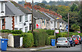
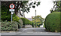
Windsor Gardens, Bangor
The northern side of a steep street, developed between 1928 and 1939, running from the Manse Road (behind me) towards a lane leading to Railwayview Street and the railway station.
Image: © Albert Bridge
Taken: 1 Oct 2013
0.09 miles
8
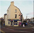
West Side Stores
This shop, on the corner of Central Avenue and Dufferin Avenue, has been open for over 100 years and always known as 'West Side Stores'.
Image: © Rossographer
Taken: 24 Oct 2007
0.10 miles
9
Drain cover, Bangor
Drain cover located in a private driveway on Osborne Drive, Bangor (house vacant at time of photograph). It is marked "J.P. Corry and Co. Ltd., 28 Talbot Street, Belfast". This is an earlier version of modern covers such as Image and Image produced by J.P. Corry http://www.jpcorry.com/ .
James P. Corry & Co. was founded by Robert Corry in 1800. By 1826 he had established a timber importing business from Canada and began purchasing a number of sailing ships to travel to and from Ireland. They were ordering ships from Harland and Wolff as far back as 1860 - in fact the iron sailing ship 'Jane Porter' was the fourth vessel launched by the yard on 1st September 1860.
Talbot Street in Belfast now looks like this Image
Image: © Rossographer
Taken: 1 May 2016
0.10 miles
10
Grays Hill
Looking up towards the Bryansburn Road.
Image: © Rossographer
Taken: 24 Oct 2007
0.10 miles