IMAGES TAKEN NEAR TO
Dufferin Avenue, BANGOR, BT20 3AD
Introduction
This page details the photographs taken nearby to Dufferin Avenue, BT20 3AD by members of the Geograph project.
The Geograph project started in 2005 with the aim of publishing, organising and preserving representative images for every square kilometre of Great Britain, Ireland and the Isle of Man.

There are currently over 7.5m images from over14,400 individuals and you can help contribute to the project by visiting https://www.geograph.org.uk
Image Map
Images are licensed for reuse under creativecommons.org/licenses/by-sa/2.0
Notes
- Clicking on the map will re-center to the selected point.
- The higher the marker number, the further away the image location is from the centre of the postcode.
Image Listing (623 Images Found)
Images are licensed for reuse under creativecommons.org/licenses/by-sa/2.0
Image
Details
Distance
1
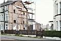
Development site, 70-74 Dufferin Avenue, Bangor (September 2015)
The properties have been demolished leaving this gap. There is the following planning permission “W/2014/0343/F 70-74 Dufferin Avenue Bangor Demolition of existing 3 no. terraced dwellings, Residential Development consisting of 11 no. 1 bed apartments including on-site parking and the partial re-surfacing of an access lane to the rear. (amended description).” The elevations available on the NI Planning Portal show a building similar in style to the surrounding houses. This photograph appears as a matter of record only. I have no connection with the developer and cannot enter into correspondence.
Image: © Albert Bridge
Taken: 1 Sep 2015
0.01 miles
2
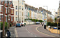
Dufferin Avenue, Bangor
See Image The view from just beyond the Southwell Road (starting close to where the previous one ended). The redbrick terrace (circa 1895) is an island in a sea of stucco. The building beyond the cars on the left is a recent block of apartments in the general style of the street.
Image: © Albert Bridge
Taken: 2 Mar 2010
0.02 miles
3
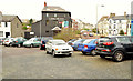
Catherine Place, Bangor (March 2014)
The site is currently used as an unofficial car park. The agent’s board (background) now has a “sold” patch. Dufferin Avenue is to the right.
Image: © Albert Bridge
Taken: 5 Mar 2014
0.03 miles
4
The West Side Stores, Bangor
See Image The shop now seems to have closed.
Image: © Albert Bridge
Taken: 14 Jun 2011
0.04 miles
5
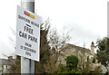
Car park, Dufferin Avenue, Bangor (2)
See Image A sign confirming that the car park is free.
Image: © Albert Bridge
Taken: 5 Mar 2014
0.05 miles
6
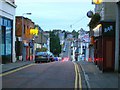
Central Avenue
Looking towards Bryansburn Road in the distance.
Image: © Rossographer
Taken: 7 Oct 2007
0.05 miles
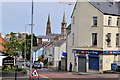
7
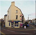
West Side Stores
This shop, on the corner of Central Avenue and Dufferin Avenue, has been open for over 100 years and always known as 'West Side Stores'.
Image: © Rossographer
Taken: 24 Oct 2007
0.05 miles
8
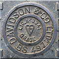
Manhole cover, Bangor
Detail of another Davidson manhole cover similar to Image and Image
This one is in a car park at Dufferin Avenue, Bangor Image
Image: © Rossographer
Taken: 2 May 2012
0.05 miles
9
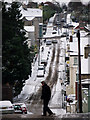
Central Avenue, Bangor
Central Avenue in Bangor during the cold spell in December 2010. Around 2-3 inches fell on the town centre on the night of 16th/17th December 2010; this persisted on the ground and was topped up by a further 3-4 inches a few days later. The cold spell saw persistent sub-zero temperatures in the town and at one point the marina had partially frozen over - see Image A thaw did not set in until the 27th December.
Central Avenue is a straight road leading from Main Street to Dufferin Avenue, although it dips dramatically between the two as it crosses Southwell Road.
The street features on maps from 1833, although buildings were only developed after 1860. It was known as either Middle Road or Diocesan Road in the mid 19th Century. See also Image
Image: © Rossographer
Taken: 17 Dec 2010
0.05 miles
10

'Alliance' election poster, Bangor
European election poster for Anna Lo of the Alliance Party of Northern Ireland http://allianceparty.org/ . This one was at Dufferin Avenue in Bangor.
Image: © Rossographer
Taken: 19 Apr 2014
0.05 miles