IMAGES TAKEN NEAR TO
Linen Place, BANGOR, BT19 7JX
Introduction
This page details the photographs taken nearby to Linen Place, BT19 7JX by members of the Geograph project.
The Geograph project started in 2005 with the aim of publishing, organising and preserving representative images for every square kilometre of Great Britain, Ireland and the Isle of Man.

There are currently over 7.5m images from over14,400 individuals and you can help contribute to the project by visiting https://www.geograph.org.uk
Image Map
Images are licensed for reuse under creativecommons.org/licenses/by-sa/2.0
Notes
- Clicking on the map will re-center to the selected point.
- The higher the marker number, the further away the image location is from the centre of the postcode.
Image Listing (4 Images Found)
Images are licensed for reuse under creativecommons.org/licenses/by-sa/2.0
Image
Details
Distance
1
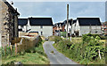
Track, Green Road, Bangor (July 2017)
See Image (October 2007). The track (known locally as Gibson’s Lane) has been developed as predicted in the link.
Image: © Albert Bridge
Taken: 14 Jul 2017
0.20 miles
2
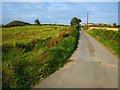
Track near Conlig
Track off the Green Road near Conlig. Houses (like those in the distance) on the edge of Bangor near Rathgill will soon be built up to the end of the road.
Update - some 10 years later the predicted development had indeed reached this area as seen in Image
Image: © Rossographer
Taken: 14 Oct 2007
0.21 miles
3
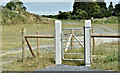
Gate, Green Road, Bangor (July 2017)
Image: © Albert Bridge
Taken: 14 Jul 2017
0.23 miles
4
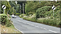
The Green Road, Bangor (July 2017)
A road of two distinct parts. The stretch from the ring road roundabout (behind me) is pure suburbia. This section is a minor road running to the Six Road Ends Image
Image: © Albert Bridge
Taken: 14 Jul 2017
0.24 miles