IMAGES TAKEN NEAR TO
Orlock Road, BANGOR, BT19 6LW
Introduction
This page details the photographs taken nearby to Orlock Road, BT19 6LW by members of the Geograph project.
The Geograph project started in 2005 with the aim of publishing, organising and preserving representative images for every square kilometre of Great Britain, Ireland and the Isle of Man.

There are currently over 7.5m images from over14,400 individuals and you can help contribute to the project by visiting https://www.geograph.org.uk
Image Map
Images are licensed for reuse under creativecommons.org/licenses/by-sa/2.0
Notes
- Clicking on the map will re-center to the selected point.
- The higher the marker number, the further away the image location is from the centre of the postcode.
Image Listing (20 Images Found)
Images are licensed for reuse under creativecommons.org/licenses/by-sa/2.0
Image
Details
Distance
1
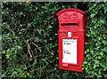
Postbox, Orlock
George VI postbox located on the Orlock Road (BT19 609).
Image: © Rossographer
Taken: 14 Jul 2009
0.02 miles
2
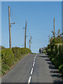
Orlock Road, Orlock
Quiet road off the main A2 serving houses and farmland at Orlock and Sandeel Bay.
Image: © Rossographer
Taken: 3 May 2020
0.04 miles
3
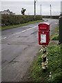
Postbox, Orlock
A festive post mounted George VI letterbox (BT19 609) at Orlock near Donaghadee.
Image: © Rossographer
Taken: 26 Dec 2020
0.05 miles
4
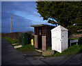
Shelter, Orlock
A small shelter on the corner of Orlock Road and Coastguard Lane. It appears to be a privately built bus shelter.
Image: © Rossographer
Taken: 7 Jan 2012
0.05 miles
5
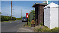
Shelter and postbox, Orlock
Shelter (bus stop) at Orlock near Donaghadee, last seen in Image The postbox is seen in more detail at Image and there is a bench mark in the large stone Image
Image: © Rossographer
Taken: 25 May 2020
0.05 miles
6
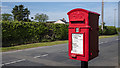
Postbox, Orlock
Post mounted George VI letterbox (BT19 609) at Orlock near Donaghadee Image It was previously sited across the road Image but may have been getting lost in hedging so was moved here.
Image: © Rossographer
Taken: 25 May 2020
0.05 miles
7
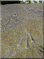
Bench Mark, Orlock
Rivet bench mark in a large stone on the corner of Orlock Road and Coastguard Lane, Orlock Image
The mark has been levelled to 28.96 metres above MSL.
Image: © Rossographer
Taken: 25 May 2020
0.05 miles
8
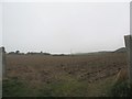
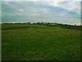
Arable farm land between the Orlock Road and the A2
Image: © Eric Jones
Taken: 28 Mar 2017
0.12 miles
9
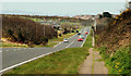
The Donaghadee Road, near Groomsport
A straight section of the Donaghadee – Bangor road, looking towards Bangor, near Orlock. Groomsport is at top right.
Image: © Albert Bridge
Taken: 9 Apr 2010
0.13 miles
10
Towards Orlock
Looking across fields near the shore towards Orlock.
Image: © Rossographer
Taken: 4 Nov 2007
0.14 miles