IMAGES TAKEN NEAR TO
Sandeel Lane, BANGOR, BT19 6LP
Introduction
This page details the photographs taken nearby to Sandeel Lane, BT19 6LP by members of the Geograph project.
The Geograph project started in 2005 with the aim of publishing, organising and preserving representative images for every square kilometre of Great Britain, Ireland and the Isle of Man.

There are currently over 7.5m images from over14,400 individuals and you can help contribute to the project by visiting https://www.geograph.org.uk
Image Map
Images are licensed for reuse under creativecommons.org/licenses/by-sa/2.0
Notes
- Clicking on the map will re-center to the selected point.
- The higher the marker number, the further away the image location is from the centre of the postcode.
Image Listing (20 Images Found)
Images are licensed for reuse under creativecommons.org/licenses/by-sa/2.0
Image
Details
Distance
1
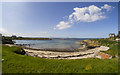
Sandeel Bay, Orlock
Small sandy bay at Orlock between Groomsport and Donaghadee.
Image: © Rossographer
Taken: 14 May 2016
0.02 miles
2
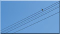
Swallow, Orlock
Solitary swallow on telegraph wires at Orlock - the first I'd seen in 2020 although some were spotted locally at least a week earlier.
Image: © Rossographer
Taken: 3 May 2020
0.02 miles
3
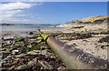
Old pipeline, Sandeel Bay
Old cast iron pipe running out into Sandeel Bay, Orlock Image It looks like a disused sewerage outfall.
Image: © Rossographer
Taken: 14 May 2016
0.03 miles
4
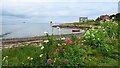
Sandeel Bay, Groomsport and wild flowers
Image: © Colin Park
Taken: 11 Sep 2023
0.04 miles
5
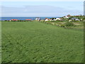
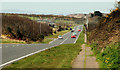
View north to Sandeel Bay
A spring afternoon by the A2 between Bangor and Donaghadee.
Image: © Jonathan Billinger
Taken: 17 May 2007
0.09 miles
6
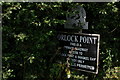
Sign at Sandeel Lane, Orlock
Sandeel Lane is a private lane leading to Orlock Point, Sandeel Bay and some houses. This is the National Trust sign at the start of the lane.
Image: © Albert Bridge
Taken: 30 Jul 2006
0.10 miles
7
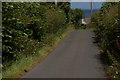
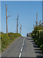
Sandeel Lane, Orlock
The Orlock Road falls into two squares. The Bangor end is in J5583. Sandeel Lane runs off this section of the road and leads to Orlock Point, Sandeel Bay and some houses. It is a private road with access allowed, on foot, to non-residents.
Image: © Albert Bridge
Taken: 30 Jul 2006
0.10 miles
8
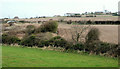
Fields near Orlock, Groomsport
Fields between the Donaghadee and Orlock Roads with the Orlock coastguard station at top right.
Image: © Albert Bridge
Taken: 9 Apr 2010
0.16 miles
9
Orlock Road, Orlock
Quiet road off the main A2 serving houses and farmland at Orlock and Sandeel Bay.
Image: © Rossographer
Taken: 3 May 2020
0.18 miles
10
The Donaghadee Road, near Groomsport
A straight section of the Donaghadee – Bangor road, looking towards Bangor, near Orlock. Groomsport is at top right.
Image: © Albert Bridge
Taken: 9 Apr 2010
0.20 miles