IMAGES TAKEN NEAR TO
Bayview Road, BANGOR, BT19 6AL
Introduction
This page details the photographs taken nearby to Bayview Road, BT19 6AL by members of the Geograph project.
The Geograph project started in 2005 with the aim of publishing, organising and preserving representative images for every square kilometre of Great Britain, Ireland and the Isle of Man.

There are currently over 7.5m images from over14,400 individuals and you can help contribute to the project by visiting https://www.geograph.org.uk
Image Map
Images are licensed for reuse under creativecommons.org/licenses/by-sa/2.0
Notes
- Clicking on the map will re-center to the selected point.
- The higher the marker number, the further away the image location is from the centre of the postcode.
Image Listing (7 Images Found)
Images are licensed for reuse under creativecommons.org/licenses/by-sa/2.0
Image
Details
Distance
1
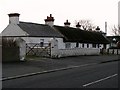
Thatched cottages, Ballymacormick Road, Bangor
The thatched cottages on the right are named Duquesne and Avoca and were built around 1800. I can still remember when the rest of this road was largely composed of small single storey brick and wooden cottages; today these are the only remarkable houses in an otherwise bland suburban road on the edge of Bangor. Currently only the southern side of Ballymacormick Road has been developed; with the exception of Ballymacormick House the northern side is still green belt, though under constant threat of development.
Image: © Rossographer
Taken: 2 Mar 2008
0.05 miles
2
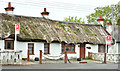
Thatched cottages, Ballymacormick Road, Bangor (May 2017)
See Image (March 2008). Two thatched cottages, at 34-36 Ballymacormick Road, now offered for sale. The agents’ description includes “We are delighted to offer to the market this unique opportunity to acquire this thatched semi detached cottage with outbuildings and gardens to rear, lending itself to potential for redevelopment, subject to relevant approvals. The existing property and outbuildings are in need of extensive modernisation and updating should the discerning buyer wish to refurbish them. Situated in a popular and convenient location a short distance from Ballyholme beach, schools, yacht clubs and near to walks to Groomsport.” Image shows the site after demolition.
I have no connection with any of the parties involved in the sale.
Image: © Albert Bridge
Taken: 25 May 2017
0.08 miles
3
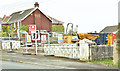
Nos 34-36 Ballymacormick Road (demolition), Bangor (April 2018)
See Image Now demolished.
Image: © Albert Bridge
Taken: 24 Apr 2018
0.09 miles
4
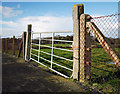
Field gate, Bangor
Gate leading to farmland from the Ballymacormick Road on the northern edge of Bangor.
Image: © Rossographer
Taken: 30 Jan 2010
0.09 miles
5
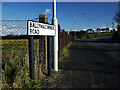
The Ballymacormick Road, Bangor
Road on the northern edge of Bangor leading from the East Circular Road. The northern side of the road is green belt and, aside from Ballymacormick House, all development is along the southern side of the road only. Image shows the very end of the road.
Image: © Rossographer
Taken: 30 Jan 2010
0.17 miles
6
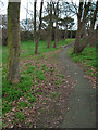
Woodland, Bangor
Small wooded area between Plantation Road and Kenbrooke Crescent in Bangor. This area appears to have been preserved as a small woodland walk when the area was developed in the late 1960s / early 1970s. I doubt if this would happen today.
Image: © Rossographer
Taken: 26 Dec 2008
0.17 miles
7
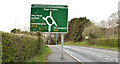
Roundabout sign, Ballyholme, Bangor
A roundabout sign, approaching the Groomsport Road roundabout at Ballyholme from the single-carriageway Groomsport bypass Image The road continues as a dual carriageway, via the ring road Image, towards the Belfast Road Image
Image: © Albert Bridge
Taken: 25 Apr 2013
0.25 miles