IMAGES TAKEN NEAR TO
High Street, HOLYWOOD, BT18 9AT
Introduction
This page details the photographs taken nearby to High Street, BT18 9AT by members of the Geograph project.
The Geograph project started in 2005 with the aim of publishing, organising and preserving representative images for every square kilometre of Great Britain, Ireland and the Isle of Man.

There are currently over 7.5m images from over14,400 individuals and you can help contribute to the project by visiting https://www.geograph.org.uk
Image Map
Images are licensed for reuse under creativecommons.org/licenses/by-sa/2.0
Notes
- Clicking on the map will re-center to the selected point.
- The higher the marker number, the further away the image location is from the centre of the postcode.
Image Listing (280 Images Found)
Images are licensed for reuse under creativecommons.org/licenses/by-sa/2.0
Image
Details
Distance
1
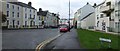
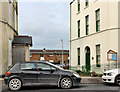
High Street, Holywood
Heading west towards the town centre
Image: © Kenneth Allen
Taken: 11 Dec 2009
0.01 miles
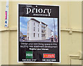
2
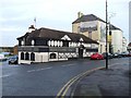
Olde Priory Bar, Holywood
Looking ENE along High Street
Image: © Kenneth Allen
Taken: 11 Dec 2009
0.01 miles
3
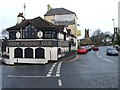
B198, High Street, Holywood
Heading eastwards, on the left is the Olde Priory Bar; in the distance is the Priory and First Holywood Presbyterian Church
Image: © Kenneth Allen
Taken: 11 Dec 2009
0.01 miles
4
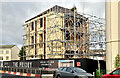
The Priory apartments site, Holywood - September 2018(1)
The former Maryville House, surrounded by scaffolding, during renovation and conversion to apartments.
Image: © Albert Bridge
Taken: 16 Sep 2018
0.01 miles
5
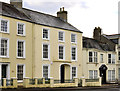
Nos 2-6 High Street, Holywood
Three properties at the Bangor end of High Street (Bangor Road on the Google map).
No 2 (left) is not listed but is mentioned on the list as “An attached corner-sited L-shaped late-nineteenth century house, located at the junction of High Street and Victoria Road, Holywood . . . . . The house is unremarkable within the context of the area, and is not considered to be of special interest.”
No 4 is listed as HB23/20/005 without a description.
No 6 - Rollo House (right) is listed as HB23/20/006 without a description.
Image: © Albert Bridge
Taken: 10 Dec 2011
0.02 miles
6
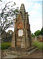
Memorial, Holywood
Memorial standing just outside the front of the old priory in Holywood. It records the death of two friends, James Withers and Edwin Henderson, who were killed in a boating incident in Belfast Lough on 16th August 1873. They were on board the racing gig 'Vidette'. See Image for a picture of the inscription.
Image: © Rossographer
Taken: 9 Jun 2008
0.02 miles
7
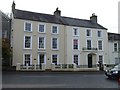
Rollo House, Holywood
It is located along High Street
Image: © Kenneth Allen
Taken: 11 Dec 2009
0.02 miles
8
No3 Stewart's Place, Holywood
A former house, built circa 1840 and restored in 1992/3. The derelict Maryville House (1 Stewart’s Place) Image is on the left. The Google map correctly shows Stewart’s Place to the west. Although not shown as such, this is also Stewart’s Place – see the name sign at the car bonnet (right).
Image: © Albert Bridge
Taken: 2 Mar 2012
0.02 miles
9
"The Priory" development site, Holywood (4)
The joint agents’ sign, on “Maryville House”, incorporating the architects’ impression of the proposed replacement apartments.
Image: © Albert Bridge
Taken: 7 Oct 2013
0.02 miles
10
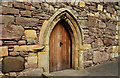
The Priory church, Holywood (2)
The door on the High Street side.
Image: © Albert Bridge
Taken: 9 Aug 2011
0.02 miles