IMAGES TAKEN NEAR TO
Killeaton Park, BELFAST, BT17 9HE
Introduction
This page details the photographs taken nearby to Killeaton Park, BT17 9HE by members of the Geograph project.
The Geograph project started in 2005 with the aim of publishing, organising and preserving representative images for every square kilometre of Great Britain, Ireland and the Isle of Man.

There are currently over 7.5m images from over14,400 individuals and you can help contribute to the project by visiting https://www.geograph.org.uk
Image Map
Images are licensed for reuse under creativecommons.org/licenses/by-sa/2.0
Notes
- Clicking on the map will re-center to the selected point.
- The higher the marker number, the further away the image location is from the centre of the postcode.
Image Listing (41 Images Found)
Images are licensed for reuse under creativecommons.org/licenses/by-sa/2.0
Image
Details
Distance
1
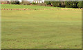
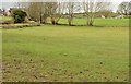
Fields, Derriaghy (2)
Fields at the northern end of the Killeaton Amenity Area.
Image: © Albert Bridge
Taken: 16 Feb 2013
0.07 miles
2
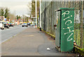
Traffic counter, Derriaghy
A traffic counter, at Queensway, beside Derriaghy Cricket Club (right).
Image: © Albert Bridge
Taken: 16 Feb 2013
0.08 miles
3
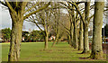
Trees, Derriaghy
Two lines of trees close to Queensway (right). The Goole map and the satellite photograph do not quite coincide.
Image: © Albert Bridge
Taken: 16 Feb 2013
0.08 miles
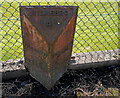
4
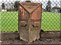
Milepost, Derriaghy
A milepost, at Queensway, outside Derriaghy cricket ground, showing the distances to Lisburn as 2½ miles, Belfast 6 miles and Hillsbro (Hillsborough) 4¾ miles (statute).
Image: © Albert Bridge
Taken: 7 Jan 2012
0.08 miles
5
Milepost, Derriaghy
A milepost, at Queensway, outside Derriaghy cricket ground, showing the distances to Lisburn as 2½ miles, Belfast 6 miles and Hillsbro (Hillsborough) 4¾ miles (statute). The post is in poor condition and the distance to Hillsborough is none too clear. A much clearer photograph of this can be seen at Image (January 2012).
Image: © Albert Bridge
Taken: 7 Apr 2010
0.10 miles
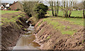
6
The Killeaton River, Derriaghy (2)
See Image The Killeaton River about to go underground at Queensway. The Goole map and the satellite photograph do not quite coincide.
Image: © Albert Bridge
Taken: 16 Feb 2013
0.11 miles
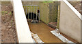
7
The Killeaton River, Derriaghy (1)
This majestic watercourse isn’t shown on the 1:50,000 map or the 1:12,000 Greater Belfast street map. It’s a stream which flows into the Lagan somewhere between Derriaghy and Lambeg. This view (upstream), from close to where it goes underground at Queensway, shows some recent work done under what seems to be the “Minor/Urban Watercourse Maintenance Programme A 2012/2013 - Greater Belfast”. The fields on the right have public access and used to be known as the “Killeaton Amenity Area”. The Goole map and the satellite photograph do not quite coincide. Image shows the stream about to pass under Queensway.
Image: © Albert Bridge
Taken: 16 Feb 2013
0.11 miles
8
Fields, Derriaghy (1)
Fields at the north western end of the Killeaton Amenity Area. The Killeaton River Image is behind the bank at top left.
Image: © Albert Bridge
Taken: 16 Feb 2013
0.12 miles
9
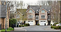
The Rose Garden, Derriaghy - April 2016(3)
An earlier (completed and occupied) part of the development, seen from Queensway.
Image: © Albert Bridge
Taken: 14 Apr 2016
0.13 miles
10
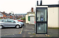
Telephone box, Derriaghy
Telephone box, at the corner of Killeaton Crescent (background) and Queensway, close to Image Today was the first real frost of the 2012/13 winter. The box looks a bit misty as the frost starts to thaw.
Image: © Albert Bridge
Taken: 24 Nov 2012
0.14 miles