IMAGES TAKEN NEAR TO
Upper Dunmurry Lane, BELFAST, BT17 0PT
Introduction
This page details the photographs taken nearby to Upper Dunmurry Lane, BT17 0PT by members of the Geograph project.
The Geograph project started in 2005 with the aim of publishing, organising and preserving representative images for every square kilometre of Great Britain, Ireland and the Isle of Man.

There are currently over 7.5m images from over14,400 individuals and you can help contribute to the project by visiting https://www.geograph.org.uk
Image Map
Images are licensed for reuse under creativecommons.org/licenses/by-sa/2.0
Notes
- Clicking on the map will re-center to the selected point.
- The higher the marker number, the further away the image location is from the centre of the postcode.
Image Listing (120 Images Found)
Images are licensed for reuse under creativecommons.org/licenses/by-sa/2.0
Image
Details
Distance
1
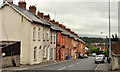
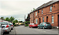
Maryville Terrace, Dunmurry
A terrace of traditional redbrick houses, some of which are now rendered, on the northern side of Upper Dunmurry Lane.
Image: © Albert Bridge
Taken: 1 Aug 2011
0.01 miles
2
Upper Dunmurry Lane, Dunmurry (2013)
See Image (August 2011). Upper Dunmurry Lane looking uphill, in the opposite direction. The Glebe Road Image is on the left.
Image: © Albert Bridge
Taken: 31 Aug 2013
0.04 miles
3
Upper Dunmurry Lane, Dunmurry
The westward continuation of Dunmurry Lane http://www.geograph.org.uk/snippet/3834 from Dunmurry crossroads to the Stewartstown Road. This view is downhill to Dunmurry, from close to Sunnymede Park. Image shows the view in the opposite direction in August 2013.
Image: © Albert Bridge
Taken: 1 Aug 2011
0.04 miles
4
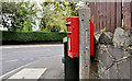
Letter box, Dunmurry
Post-mounted EIIR letter box at the corner of Areema Drive and Upper Dunmurry Lane (background).
Image: © Albert Bridge
Taken: 1 Aug 2011
0.07 miles
5
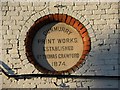
Plaque, Dunmurry Print Works
They were established in 1874, but now the building is a specialist repair garage - see Image]
Image: © Kenneth Allen
Taken: 8 Mar 2010
0.08 miles
6
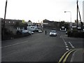
The Glebe Road, Dunmurry
A road running from Upper Dunmurry Lane (behind me) to Kingsway. It crosses the railway by a level crossing Image (below the bright roof – background).
Image: © Albert Bridge
Taken: 1 Aug 2011
0.08 miles
7
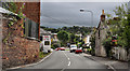
Upper Dunmurry Lane
Heading north-west
Image: © Kenneth Allen
Taken: 8 Mar 2010
0.08 miles
8
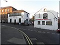
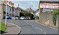
Eurofix Car Repairs, Dunmurry
They specialise in Alfa Romeo cars; this building used to be a printing works, see close-up of plaque here Image]
Image: © Kenneth Allen
Taken: 8 Mar 2010
0.08 miles
10
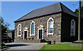
First Dunmurry (Non-Subscribing) Presbyterian church (2013)
A church on the Glebe Road, built in 1779, attributed to Roger Mulholland (1740-1818) who also designed this one Image Described in Image (September 2005) and last seen in Image (October 2009).
Image: © Albert Bridge
Taken: 17 Jul 2013
0.10 miles