IMAGES TAKEN NEAR TO
Rockmount, BELFAST, BT16 2BY
Introduction
This page details the photographs taken nearby to Rockmount, BT16 2BY by members of the Geograph project.
The Geograph project started in 2005 with the aim of publishing, organising and preserving representative images for every square kilometre of Great Britain, Ireland and the Isle of Man.

There are currently over 7.5m images from over14,400 individuals and you can help contribute to the project by visiting https://www.geograph.org.uk
Image Map
Images are licensed for reuse under creativecommons.org/licenses/by-sa/2.0
Notes
- Clicking on the map will re-center to the selected point.
- The higher the marker number, the further away the image location is from the centre of the postcode.
Image Listing (63 Images Found)
Images are licensed for reuse under creativecommons.org/licenses/by-sa/2.0
Image
Details
Distance
1
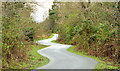
The Comber Greenway, Dundonald (9)
Further on towards the site of Dundonald station, looking back towards here Image, the path passes through an area where the south western side is particularly damp. The squiggles are more exaggerated than in the previous photograph.
Image: © Albert Bridge
Taken: 29 Jan 2014
0.05 miles
2
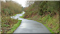
The Comber Greenway, Dundonald (8)
The Greenway, although built of the course of the old railway, does not quite run in a straight line. The path tends to avoid the damp ground – in this case through the use of a few squiggles. The view is back towards Grand Prix Park Image
Image: © Albert Bridge
Taken: 29 Jan 2014
0.05 miles
3
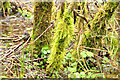
Mossy trees, Dundonald
Mossy trees, growing in very damp ground on the south western side of the Comber Greenway, close to here Image
Image: © Albert Bridge
Taken: 29 Jan 2014
0.07 miles
4
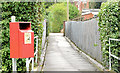
Dog bin, Dundonald (November 2014)
See Image (June 2014). A dog-dirt bin beside a path from Moat Park to the Comber Road.
Image: © Albert Bridge
Taken: 28 Nov 2014
0.07 miles
5
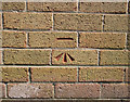
Bench Mark, Dundonald
Cut bench mark located on a gospel hall on the Comber Road in Dundonald Image
The mark is 21.06 metres above MSL.
Image: © Rossographer
Taken: 4 Jun 2010
0.07 miles
6
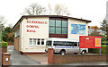
Dundonald Gospel Hall
Modern gospel hall on the Comber Road. See also Image
Image: © Albert Bridge
Taken: 22 Nov 2012
0.08 miles
7
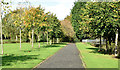
Moat Park, Dundonald (October 2014)
Autumn colours starting to appear in the trees near the Comber Road.
Image: © Albert Bridge
Taken: 6 Oct 2014
0.08 miles
8
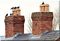
Chimneys and pigeons, Dundonald
Feral pigeons, at rest, on house chimneys beside the Comber Road.
Image: © Albert Bridge
Taken: 29 Jan 2014
0.11 miles
9
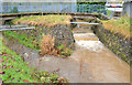
Confluence, Dundonald
The confluence, in Moat Park, of two streams – this one Image (left) and Image to form the Enler River Image Both are fast and muddy after heavy rain overnight.
Image: © Albert Bridge
Taken: 22 Nov 2012
0.11 miles
10
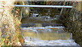
Stream, Moat Park, Dundonald (October 2014)
The stream on the right in Image in full flow after very heavy overnight rain.
Image: © Albert Bridge
Taken: 6 Oct 2014
0.11 miles