IMAGES TAKEN NEAR TO
Upper Newtownards Road, BELFAST, BT16 1UG
Introduction
This page details the photographs taken nearby to Upper Newtownards Road, BT16 1UG by members of the Geograph project.
The Geograph project started in 2005 with the aim of publishing, organising and preserving representative images for every square kilometre of Great Britain, Ireland and the Isle of Man.

There are currently over 7.5m images from over14,400 individuals and you can help contribute to the project by visiting https://www.geograph.org.uk
Image Map
Images are licensed for reuse under creativecommons.org/licenses/by-sa/2.0
Notes
- Clicking on the map will re-center to the selected point.
- The higher the marker number, the further away the image location is from the centre of the postcode.
Image Listing (10 Images Found)
Images are licensed for reuse under creativecommons.org/licenses/by-sa/2.0
Image
Details
Distance
1
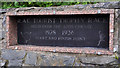
Ards TT plaque, Dundonald
The Ards TT was a motor race over 13½ miles of public roads. The course started here, on the Upper Newtownards Road, Dundonald and ran via Newtownards (over Bradshaw’s Brae) and Comber. The first race was in 1928. The last in 1936 during which a competitor’s car crashed killing eight spectators. Image shows the equivalent memorial in Newtownards.
This YouTube video shows a lap of the course in 2007 http://www.youtube.com/watch?v=WvbqCuo5ePg.
Image: © Albert Bridge
Taken: 26 Jun 2011
0.04 miles
2
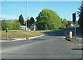
The entrance to Carrowreagh Road
This image was taken from the Upper Newtownards Road.
Image: © Eric Jones
Taken: 21 May 2012
0.10 miles
3
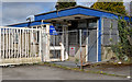
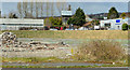
The Rolls-Royce site, Dundonald (2013-3)
The former security office, facing the Carrowreagh Road.
Image: © Albert Bridge
Taken: 18 Apr 2013
0.12 miles
4
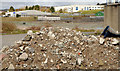
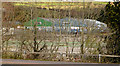
The Rolls-Royce site, Dundonald (2013-2)
A pile of rubble, inside the fence, close to the Carrowreagh Road.
Image: © Albert Bridge
Taken: 18 Apr 2013
0.12 miles
5

Old European Components Corporation sign, Dundonald
Rolls Royce (Dundonald), Fisher Body, ECC and the factory have all passed into history but this sign remains, attached to a rusty fence, on the Carrowreagh Road.
Image: © Albert Bridge
Taken: 30 Apr 2014
0.13 miles
6
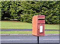
Postbox BT16 400, Dundonald
Post-mounted EIIR postbox (BT16 400) at Old Mill Heights (Old Mill Meadows on the Google map).
Image: © Albert Bridge
Taken: 16 Oct 2014
0.16 miles
7
The Rolls-Royce site, Dundonald (2013-4)
The site seen through the leafless trees on the Upper Newtownards Road.
Image: © Albert Bridge
Taken: 18 Apr 2013
0.18 miles
8
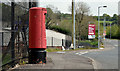
Pillar box BT16 402, Dundonald
EIIR pillar box (BT16 402) on the Carrowreagh Road.
Image: © Albert Bridge
Taken: 30 Apr 2014
0.18 miles
9
The Rolls-Royce site, Dundonald (2013-1)
Part of the site close to the northern side of the Upper Newtownards Road.
Image: © Albert Bridge
Taken: 18 Apr 2013
0.20 miles
10
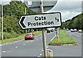
"Cats Protection" sign, Dundonald (July 2017)
The charity “Cats Protection” https://en.wikipedia.org/wiki/Cats_Protection occupies premises between Quarry Corner and Bradshaw’s Brae.
Image: © Albert Bridge
Taken: 14 Jul 2017
0.25 miles