IMAGES TAKEN NEAR TO
The Close, Millars Forge, BELFAST, BT16 1QS
Introduction
This page details the photographs taken nearby to The Close, Millars Forge, BT16 1QS by members of the Geograph project.
The Geograph project started in 2005 with the aim of publishing, organising and preserving representative images for every square kilometre of Great Britain, Ireland and the Isle of Man.

There are currently over 7.5m images from over14,400 individuals and you can help contribute to the project by visiting https://www.geograph.org.uk
Image Map
Images are licensed for reuse under creativecommons.org/licenses/by-sa/2.0
Notes
- Clicking on the map will re-center to the selected point.
- The higher the marker number, the further away the image location is from the centre of the postcode.
Image Listing (47 Images Found)
Images are licensed for reuse under creativecommons.org/licenses/by-sa/2.0
Image
Details
Distance
1
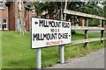
Millmount Road/Millmount Chase name signs, Dundonald (August 2015)
Combined name signs, showing the townland as Ballymaglaff, on the Millmount Road Image
Image: © Albert Bridge
Taken: 1 Aug 2015
0.05 miles
2
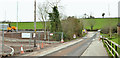
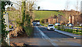
Millmount Village, Dundonald - March 2014(1)
The Millmount Road, looking towards the Comber Road, with the new Millmount Village road under construction on the left. It appears that the present line will become a cul-de-sac with access (lower left) from the new road.
Image: © Albert Bridge
Taken: 22 Mar 2014
0.06 miles
3
The Millmount Road, Dundonald - May 2014(1)
The Millmount Road Image (January 2009) is now the old line of the Millmount Road, stopped up at the Comber Road end, and used as an access from the new line (behind the hedge on the left) to Millmount Chase (out of picture to the right).
Image: © Albert Bridge
Taken: 5 May 2014
0.06 miles
4
The Millmount Road, Dundonald (1)
The Millmount Road runs off the Comber Road (background) towards the main Belfast – Newtownards road. Back in 1963 the Matthew Plan envisaged a novelty which came to be known as the “Matthew Stop Line” ie a limit on the outward development of Belfast. It has not been taken too seriously. This photo shows the eastern limit of greater Belfast. Fields to the left and suburbs to the right. See also Image Image shows the road after stopping-up as part of the Millmount Village development.
Image: © Albert Bridge
Taken: 29 Jan 2009
0.06 miles
5
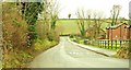
The Millmount Road, Dundonald (3)
The Millmount Road, looking towards the Comber Road. The Millmount Village site is on the left.
Image: © Albert Bridge
Taken: 28 Dec 2013
0.07 miles
6
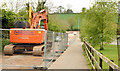
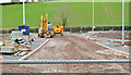
Millmount Village, Dundonald (1 in December 2013)
The view towards Comber at the corner of the Millmount Road. Work is underway in building the access roads and widening the Comber Road.
Image: © Albert Bridge
Taken: 9 Dec 2013
0.07 miles
7
Millmount Village, Dundonald - March 2014(2)
The new access road, from the Comber Road (background), seen from the temporarily re-aligned Comber Greenway Image
Image: © Albert Bridge
Taken: 22 Mar 2014
0.07 miles
8
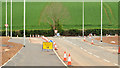
The Millmount Road, Dundonald - May 2014(2)
See Image The new alignment of the Millmount Road, looking towards the Comber Road. This short stretch has been realigned, as far as the Enler Bridge, to serve the Millmount Village development. The old line is out of picture to the right.
Image: © Albert Bridge
Taken: 5 May 2014
0.08 miles
9
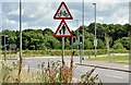
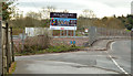
"Cycles crossing" and "pedestrians in road" signs, Dundonald (August 2015)
“Cycles crossing” and “pedestrians in road” signs, on the Millmount Road, where the Comber Greenway crosses at this roundabout Image See also Image (January 2009).
Image: © Albert Bridge
Taken: 1 Aug 2015
0.08 miles
10
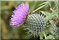
Thistle, Comber Greenway, Dundonald (August 2015)
A thistle, at the height of flowering, growing along the Comber Greenway, beside the Millmount Road entrance.
Image: © Albert Bridge
Taken: 1 Aug 2015
0.09 miles