IMAGES TAKEN NEAR TO
Carrowreagh Business Park, Carrowreagh Road, BELFAST, BT16 1QQ
Introduction
This page details the photographs taken nearby to Carrowreagh Business Park, Carrowreagh Road, BT16 1QQ by members of the Geograph project.
The Geograph project started in 2005 with the aim of publishing, organising and preserving representative images for every square kilometre of Great Britain, Ireland and the Isle of Man.

There are currently over 7.5m images from over14,400 individuals and you can help contribute to the project by visiting https://www.geograph.org.uk
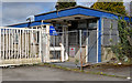
Image Map
Images are licensed for reuse under creativecommons.org/licenses/by-sa/2.0
Notes
- Clicking on the map will re-center to the selected point.
- The higher the marker number, the further away the image location is from the centre of the postcode.
Image Listing (16 Images Found)
Images are licensed for reuse under creativecommons.org/licenses/by-sa/2.0
Image
Details
Distance
1
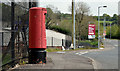
Pillar box BT16 402, Dundonald
EIIR pillar box (BT16 402) on the Carrowreagh Road.
Image: © Albert Bridge
Taken: 30 Apr 2014
0.12 miles
2
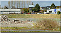
The Rolls-Royce site, Dundonald (2013-1)
Part of the site close to the northern side of the Upper Newtownards Road.
Image: © Albert Bridge
Taken: 18 Apr 2013
0.15 miles
3
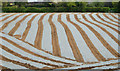
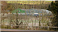
Field and plastic sheeting, Dundonald (April 2014)
A crop, sown under plastic sheeting, on the western side of the Carrowreagh Road (just outside the built-up area). This seems to be a growing trend but, as a townie, I haven’t the faintest idea what lies beneath.
Image: © Albert Bridge
Taken: 30 Apr 2014
0.16 miles
4

Old European Components Corporation sign, Dundonald
Rolls Royce (Dundonald), Fisher Body, ECC and the factory have all passed into history but this sign remains, attached to a rusty fence, on the Carrowreagh Road.
Image: © Albert Bridge
Taken: 30 Apr 2014
0.16 miles
5
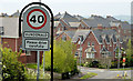
The Carrowreagh Road, Dundonald - April 2014(2)
The 40mph speed limit sign (now further out than previously), at the start of developed Dundonald, on the Carrowreagh Road. Part of the Millreagh development (still under construction) is in the background.
Image: © Albert Bridge
Taken: 30 Apr 2014
0.17 miles
6
The Rolls-Royce site, Dundonald (2013-3)
The former security office, facing the Carrowreagh Road.
Image: © Albert Bridge
Taken: 18 Apr 2013
0.19 miles
7
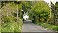
The Carrowreagh Road, Dundonald - April 2014(1)
See Image (March 2008). The view, uphill, slightly further north as the road starts to climb towards Craigantlet. The built-up part of Dundonald is just behind me.
Image: © Albert Bridge
Taken: 30 Apr 2014
0.20 miles
8
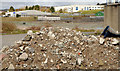
The Rolls-Royce site, Dundonald (2013-2)
A pile of rubble, inside the fence, close to the Carrowreagh Road.
Image: © Albert Bridge
Taken: 18 Apr 2013
0.20 miles
9
The Rolls-Royce site, Dundonald (2013-4)
The site seen through the leafless trees on the Upper Newtownards Road.
Image: © Albert Bridge
Taken: 18 Apr 2013
0.21 miles
10
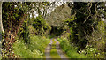
Lane, Dundonald (April 2014)
A lane running north east off the Carrowreagh Road. The Millreagh development (still under construction) is a short distance out of picture to the right.
Image: © Albert Bridge
Taken: 30 Apr 2014
0.21 miles