IMAGES TAKEN NEAR TO
Cherryhill Gardens, BELFAST, BT16 1JF
Introduction
This page details the photographs taken nearby to Cherryhill Gardens, BT16 1JF by members of the Geograph project.
The Geograph project started in 2005 with the aim of publishing, organising and preserving representative images for every square kilometre of Great Britain, Ireland and the Isle of Man.

There are currently over 7.5m images from over14,400 individuals and you can help contribute to the project by visiting https://www.geograph.org.uk
Image Map
Images are licensed for reuse under creativecommons.org/licenses/by-sa/2.0
Notes
- Clicking on the map will re-center to the selected point.
- The higher the marker number, the further away the image location is from the centre of the postcode.
Image Listing (125 Images Found)
Images are licensed for reuse under creativecommons.org/licenses/by-sa/2.0
Image
Details
Distance
1
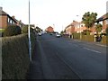
Cherryhill Park, Dundonald
Leading north from Cherryhill Drive.
Image: © Dean Molyneaux
Taken: 12 Feb 2010
0.05 miles
2
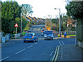
Ballyregan Road, Dundonald
The Ballyregan Road leads northwards from the main A20 Upper Newtownards Road in Dundonald village, into the hills to Craigantlet - providing a link to Holywood and the rest of North Down.
Image: © Dean Molyneaux
Taken: 12 Feb 2010
0.05 miles
3
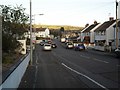
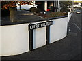
Cherryhill Road, Dundonald
The lower - and busiest - portion of this road.
Image: © Dean Molyneaux
Taken: 12 Feb 2010
0.09 miles
4
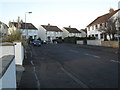
Cherryhill Crescent, Dundonald
Leading north from the Cherryhill Road.
Image: © Dean Molyneaux
Taken: 12 Feb 2010
0.09 miles
5

Mount-Regan Avenue, Dundonald (June 2014)
The view from The Moat showing how the Mount-Regan Avenue Image development marks the present limit of Dundonald. The Ulster Hospital site Image is out of picture to the left.
Image: © Albert Bridge
Taken: 28 Jun 2014
0.10 miles
6
Old sign, Cherryhill Road, Dundonald
I'm not sure which local authority put this sign up - I'd guess Castlereagh Rural District Council as Dundonald was incorporated into the Castlereagh Borough in the reforms of 1973. Probably original to the street - which sprung up in the 1960s.
Image: © Dean Molyneaux
Taken: 12 Feb 2010
0.11 miles
7
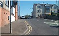
Apartment block on Ballyregan Road, Dundonald
Image: © Eric Jones
Taken: 21 May 2012
0.12 miles
8
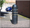
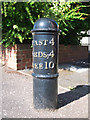
Milepost, Dundonald
Milepost on the Upper Newtownards Road, Dundonald, at the corner with St Johns Wood Park. It records that the distances to Belfast and Newtownards are both 4 miles from here; Donaghadee is 10 miles away. See also Image
Image: © Rossographer
Taken: 30 Aug 2010
0.12 miles
9
Milepost, Dundonald
Milepost on the Upper Newtownards Road, Dundonald, at the corner with St Johns Wood Park. It records that the distances to Belfast and Newtownards are both 4 miles from here; Donaghadee is 10 miles away. See also Image
Image: © Rossographer
Taken: 30 Aug 2010
0.12 miles
10
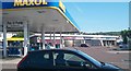
Small retail park off the Upper Newtownards Road, Dundonald
Image: © Eric Jones
Taken: 21 May 2012
0.14 miles