IMAGES TAKEN NEAR TO
Grangewood Hill, BELFAST, BT16 1GQ
Introduction
This page details the photographs taken nearby to Grangewood Hill, BT16 1GQ by members of the Geograph project.
The Geograph project started in 2005 with the aim of publishing, organising and preserving representative images for every square kilometre of Great Britain, Ireland and the Isle of Man.

There are currently over 7.5m images from over14,400 individuals and you can help contribute to the project by visiting https://www.geograph.org.uk
Image Map
Images are licensed for reuse under creativecommons.org/licenses/by-sa/2.0
Notes
- Clicking on the map will re-center to the selected point.
- The higher the marker number, the further away the image location is from the centre of the postcode.
Image Listing (24 Images Found)
Images are licensed for reuse under creativecommons.org/licenses/by-sa/2.0
Image
Details
Distance
1
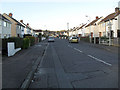
Cherryhill Road, Dundonald
The northern portion of Cherryhill Road leading to newer housing in the Grangewood development.
Image: © Dean Molyneaux
Taken: 12 Feb 2010
0.14 miles
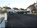
2

Canberra Gardens, Dundonald
A short cul-de-sac of bungalows off Canberra Park (Image).
Image: © Dean Molyneaux
Taken: 12 Feb 2010
0.17 miles
3
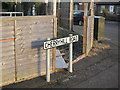
Street name sign, Cherryhill Road, Dundonald
A standard urban Castlereagh Borough Council street name sign located where Canberra Park meets the Cherryhill Road.
Image: © Dean Molyneaux
Taken: 12 Feb 2010
0.17 miles
4
Canberra Park, Dundonald
Leads from the Cherryhill Road to the Dunlady Road.
Image: © Dean Molyneaux
Taken: 12 Feb 2010
0.17 miles
5
Cherryhill Crescent, Dundonald
Leading north from the Cherryhill Road.
Image: © Dean Molyneaux
Taken: 12 Feb 2010
0.18 miles
6
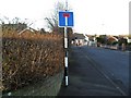
No-through road sign, Dundonald
At the bottom of Canberra Gardens at the junction with Canberra Park.
Note the pre-Worboys pole with modern sign.
Image: © Dean Molyneaux
Taken: 12 Feb 2010
0.19 miles
7
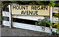
Mount Regan Avenue sign, Dundonald
See Image A sign, using the unhyphenated version, opposite the one in the link. This seems to be a standard Castlereagh Borough Council design.
Image: © Albert Bridge
Taken: 1 Nov 2013
0.19 miles
8
Cherryhill Park, Dundonald
Leading north from Cherryhill Drive.
Image: © Dean Molyneaux
Taken: 12 Feb 2010
0.19 miles
9
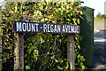
Mount - Regan Avenue sign, Dundonald
Mount-Regan Avenue is suburban housing, in a loop, on the western side of the Ballyregan Road Image This version of the name, using a hyphen, is on the northern side close to the Stoney Road and is used by the 1:12,000 OSNI street map. My guess is that this sign dates back to the days of Castlereagh Rural District Council. I can’t find any explanation for the name other than that “Regan” probably refers to the townland of Ballyregan. There doesn’t ever seem to have been a “big house” by the name of “Mount Regan” though there was a “Ballyregan House”. Image shows the unhyphenated version, opposite.
Image: © Albert Bridge
Taken: 1 Nov 2013
0.20 miles
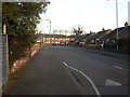
10
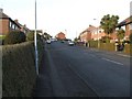
The Ballyregan Road, Dundonald
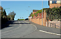
See Image (March 2012). A complete contrast as the Ballyregan Road climbs away from built-up Dundonald. The road runs north (where the car is turning) past the Grangewood development (right). The Stoney Road runs straight ahead, around the back of the Ulster Hospital, before emerging close to Dundonald House Image
Image: © Albert Bridge
Taken: 1 Nov 2013
0.20 miles