IMAGES TAKEN NEAR TO
Clifton House Mews, BELFAST, BT15 1EA

Introduction

This page details the photographs taken nearby to Clifton House Mews, BT15 1EA by members of the Geograph project.

The Geograph project started in 2005 with the aim of publishing, organising and preserving representative images for every square kilometre of Great Britain, Ireland and the Isle of Man.

There are currently over 7.5m images from over14,400 individuals and you can help contribute to the project by visiting https://www.geograph.org.uk

Image Map


Images are licensed for reuse under creativecommons.org/licenses/by-sa/2.0
Notes
  • Clicking on the map will re-center to the selected point.
  • The higher the marker number, the further away the image location is from the centre of the postcode.

Image Listing (693 Images Found)

Images are licensed for reuse under creativecommons.org/licenses/by-sa/2.0
  • ...
Image
Details
Distance
1
Belfast, Clifton House Mews
Supported housing bungalows behind Image https://www.radiushousing.org/housing/view/101094/clifton-house-mews
Image: © Mike Faherty Taken: 22 Apr 2018
0.02 miles
2
Clifton House, Belfast
Generally regarded as the oldest building in Belfast, Clifton House was built in 1771-74 as “The Charitable Society’s Poor House and Infirmary”. Continue to Image
Image: © Albert Bridge Taken: 4 Oct 2007
0.03 miles
3
Westlink, Belfast
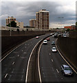
The eastern edge of the A12 'Westlink' as viewed from Clifton Street. The tower blocks behind are in the New Lodge area. Normally extremely busy throughout weekdays the road is a major throughpass which skirts the western edge of Belfast city centre and connects the M1 motorway with the M2, M3 & M5. This picture was taken at a relatively quiet period in the early evening. See http://en.wikipedia.org/wiki/Westlink_Belfast for more information on the road itself.
Image: © Rossographer Taken: 21 May 2009
0.03 miles
4
Clifton House, Belfast (4)
See Image The main entrance – facing North Queen Street. Continue to Image
Image: © Albert Bridge Taken: 1 Mar 2010
0.03 miles
5
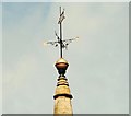
Weathervane, Belfast
A weathervane on the spire of Clifton House Image The tail includes the date “1774”.
Image: © Albert Bridge Taken: 6 Jul 2009
0.03 miles
6
Clifton House in North Queen Street
This fine Georgian building was erected in 1774 by the Belfast Charitable Society as a Poor House. Its building on land provided by Lord Donegall was financed by public subscriptions and a lottery. The building still provides accommodation for the elderly. http://www.cliftonbelfast.org.uk/history.html
Image: © Eric Jones Taken: 10 Jul 2015
0.04 miles
7
Clifton House, Belfast (5)
See Image Pediment, clock and tower (with out-of-picture spire) on the front of the building. Continue to Image
Image: © Albert Bridge Taken: 1 Mar 2010
0.04 miles
8
North Queen Park, Belfast (January 2017)
North Queen Park is built on the site of the former North Queen Street police station Image The houses are complete but some (left) are not yet occupied.
Image: © Albert Bridge Taken: 3 Jan 2017
0.04 miles
9
View north-eastwards along the Westlink (A12)
This image was taken from the Clifton Street bridge. The tower blocks are the Artillery Flats in the Nationalist New Lodge area.
Image: © Eric Jones Taken: 10 Jul 2015
0.05 miles
10
Belfast, Clifton House
A fine Georgian building on Clifton Street, built by Belfast Charitable Society in 1774 as a poorhouse. Now an events venue: http://cliftonbelfast.com/
Image: © Mike Faherty Taken: 22 Apr 2018
0.05 miles
  • ...