IMAGES TAKEN NEAR TO
Loughview Meadows, BELFAST, BT14 8QD
Introduction
This page details the photographs taken nearby to Loughview Meadows, BT14 8QD by members of the Geograph project.
The Geograph project started in 2005 with the aim of publishing, organising and preserving representative images for every square kilometre of Great Britain, Ireland and the Isle of Man.

There are currently over 7.5m images from over14,400 individuals and you can help contribute to the project by visiting https://www.geograph.org.uk
Image Map
Images are licensed for reuse under creativecommons.org/licenses/by-sa/2.0
Notes
- Clicking on the map will re-center to the selected point.
- The higher the marker number, the further away the image location is from the centre of the postcode.
Image Listing (6 Images Found)
Images are licensed for reuse under creativecommons.org/licenses/by-sa/2.0
Image
Details
Distance
1
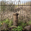
Boundary Post, Belfast
An old boundary post (damaged) on the Crumlin Road on the outskirts of Belfast.
The inscription reads:
"Parliamentary and Municipal Boundary of Belfast
Shankill Division, Shankill Ward 1918".
Image: © Rossographer
Taken: 14 Jan 2023
0.12 miles
2
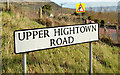
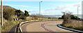
The Horseshoe Bend, Belfast - March 2014(4)
In the inward/downhill direction the bend (just about visible at middle right) starts opposite the Upper Hightown Road Image A “bend to the right” sign can be seen above the road-name sign.
Image: © Albert Bridge
Taken: 4 Mar 2014
0.16 miles
3
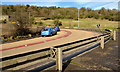
The Horseshoe Bend, Belfast - March 2014(3)
The outward/uphill view taken part way along the bend. This section of the crash barrier protects the footpath.
Image: © Albert Bridge
Taken: 4 Mar 2014
0.16 miles
4
The Horseshoe Bend, Belfast - March 2014(1)
The inward/downhill view from opposite the Upper Hightown Road Image
Image: © Albert Bridge
Taken: 4 Mar 2014
0.17 miles
5
The Horseshoe Bend, Belfast - March 2014(2)
The inward/downhill view taken part way along the bend. The crash barrier protects a short drop into the adjacent fields.
Image: © Albert Bridge
Taken: 4 Mar 2014
0.17 miles
6
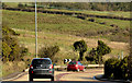
The Horseshoe Bend
The Horse Shoe Bend is on the Crumlin on the northwest outskirts of Belfast. This road used to be the main route to Belfast Airport but that changed when the M2 motorway was constructed.
Image: © Paul McIlroy
Taken: 19 May 2007
0.20 miles