IMAGES TAKEN NEAR TO
Alliance Avenue, BELFAST, BT14 7NX
Introduction
This page details the photographs taken nearby to Alliance Avenue, BT14 7NX by members of the Geograph project.
The Geograph project started in 2005 with the aim of publishing, organising and preserving representative images for every square kilometre of Great Britain, Ireland and the Isle of Man.

There are currently over 7.5m images from over14,400 individuals and you can help contribute to the project by visiting https://www.geograph.org.uk
Image Map
Images are licensed for reuse under creativecommons.org/licenses/by-sa/2.0
Notes
- Clicking on the map will re-center to the selected point.
- The higher the marker number, the further away the image location is from the centre of the postcode.
Image Listing (27 Images Found)
Images are licensed for reuse under creativecommons.org/licenses/by-sa/2.0
Image
Details
Distance
1
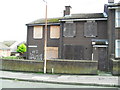
Dereliction, 37 Velsheda Court, Ardoyne
A sad sight - but common in North and West Belfast.
Image: © Dean Molyneaux
Taken: 26 Aug 2009
0.03 miles
2
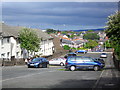
Velsheda Court, Ardoyne, Belfast
This was once all Velsheda Park - it has since been cut in two. An overwhelmingly Roman Catholic area - although in the 60s - it actually had a Protestant majority. Belfast really is 'no mean city'.
Image: © Dean Molyneaux
Taken: 26 Aug 2009
0.03 miles
3
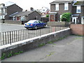
Roadblock, Velsheda Park, Ardoyne
I believe these were used to separate streets as an attempt to stop joyriders coming down the hill - plaguing residents. If anyone knows otherwise - I'd like to hear.
Image: © Dean Molyneaux
Taken: 26 Aug 2009
0.04 miles
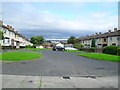
4
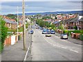
Alliance Avenue, Ardoyne, Belfast
Runs parallel to the 'Peace Wall'. This is only just on the Roman Catholic side.
Image: © Dean Molyneaux
Taken: 26 Aug 2009
0.04 miles
5
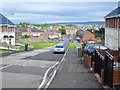
Glenbryn Park, Belfast
This is on the other side of the 'Peace Wall' visible to the right - which divides Alliance Avenue (Image) and Glenbryn Park (Roman Catholic and Protestant respectively). Since this once mixed area became a Protestant ghetto - it has become known as the Upper Ardoyne, differentiating it from the Roman Catholic Ardoyne.
Image: © Dean Molyneaux
Taken: 26 Aug 2009
0.06 miles
6
Farringdon Court, Ardoyne
Before the street was split, this was all Farringdon Gardens.
Image: © Dean Molyneaux
Taken: 26 Aug 2009
0.07 miles
7
Waste ground, Glenbryn Drive, Ardoyne
The demolition of houses here I imagine is a result of Protestants leaving the area.
Image: © Dean Molyneaux
Taken: 26 Aug 2009
0.07 miles
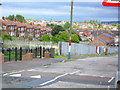
8
"The Divide", Ardoyne Road, Belfast
This is one of the most sudden and certainly one of the most contentious religious divides in Northern Ireland. In the 1960s the whole Ardoyne was a mixed area which was viewed as one step above the slums and terraces of the Shankill.
Although Protestants and Roman Catholics lived side by side as neighbours - everyone knew who was on whose side. When the conflict fired up in 1969 - suspicion arose and Protestants moved towards the northern end of the Ardoyne, towards Ballysillan which was established as Protestant. Roman Catholics, on the contrary, moved towards the Ardoyne roundabout and the Holy Cross Chapel.
This shift eventually caused an imaginary line between Alliance Avenue and Glenbryn Park. The continual violence here prompted the construction of a Peace Wall. Thankfully there has been a marked decrease in sectarian violence here since the 2001 Holy Cross dispute.
This is taken from the Protestant 'Upper Ardoyne' looking towards the Roman Catholic area - which begins roughly where the Peugeot 106 is emerging.
Image: © Dean Molyneaux
Taken: 26 Aug 2009
0.08 miles
9
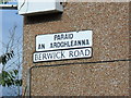
Bilingual signage, Berwick Road, Ardoyne
This is now an exclusively Roman Catholic area (not always so) - hence the use of for Irish street signs. I make no apologies for saying I am mystified as to why ratepayers' money goes into these - both for Irish and Ulster Scots. They seem to act more as 'territorial markers' than for Irish speakers.
Image: © Dean Molyneaux
Taken: 26 Aug 2009
0.10 miles
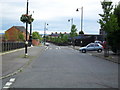
10
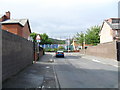
Berwick Road, Ardoyne, Belfast
Looking towards Alliance Avenue and the Peace Wall - in the 1960s, this was a mixed area (Protestants and Roman Catholics). In the times since a clear divide has been formed between Alliance Avenue and Glenbryn Park.
Image: © Dean Molyneaux
Taken: 26 Aug 2009
0.10 miles