1
Donaldson Crescent, Belfast (June 2015)
A street, built in the period after WW1, running in a loop off Twaddell Avenue. Divis and the Black Mountain are in the background.
Image: © Albert Bridge
Taken: 15 Jun 2015
0.10 miles
2
Camp Twaddell from the top of Woodvale Road
Camp Twaddell was set up in response to the 2013 decision of the Northern Ireland Parades Commission that the 12th of July Orange Parades could march past the Ardoyne shop fronts in the Catholic Ardoyne Ward on their way into the city centre in the morning, but could as was traditional not march along an 800m section of the road past the shops on their return in the evening. The marchers claim that they have not been able to return home and set up a permanent protest camp - Camp Twaddell in Twaddell Avenue close to the Ardoyne roundabout.
Image: © Eric Jones
Taken: 21 Jul 2014
0.15 miles
3
Crumlin Road at the Ardoyne
The Ardoyne is a small Roman Catholic enclave surrounded by two larger Protestant areas (Ballysillan and Shankill/Woodvale) - the violence that has been seen here since the early days of the conflict has led to it being regarded as one of the best known 'interfaces' in Belfast.
Image: © Dean Molyneaux
Taken: 25 Aug 2009
0.15 miles
4
Camp Twaddell at the junction of Twaddell Avenue and Crumlin Road
Camp Twaddell was set up in response to the 2013 decision of the Northern Ireland Parades Commission that the 12th of July Orange Parades could march past the Ardoyne shop fronts in the Catholic Ardoyne Ward on their way into the city centre in the morning, but could not march along an 800m section of the road past the shops on their return in the evening. The marchers claim that they have not been able to return home and set up a permanent protest camp - Camp Twaddell in Twaddell Avenue at the roundabout. A police presence has been maintained throughout to help preserve the peace at a cost of some £300,000 a week.
https://www.youtube.com/watch?v=nkSFAJWZVIw
Image: © Eric Jones
Taken: 21 Jul 2014
0.15 miles
5
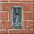
Flush Bracket, Belfast
Flush bracket bench mark on the front of the former Everton Public Elementary school on the Crumlin Road in Belfast (now part of a large Health and Social Care complex).
The number on the bracket is OSNIBM 1018.
Placed here in the 1930s, the mark only seems to appear on the 1938 plan of Belfast, levelled to 233.8 feet above sea level - unusually, I can't see it on any later maps.
Image: © Rossographer
Taken: 18 Jan 2023
0.16 miles
6
The Ardoyne Shop Fronts from the Ardoyne (Crumlin Road) roundabout
This is the 800m stretch of road past the Ardoyne Shops which has become the bone of such contention between Loyalists and Nationalists.
Image: © Eric Jones
Taken: 21 Jul 2014
0.16 miles
7
Shops at the Ardoyne
At the start of Ardoyne Road.
Image: © Dean Molyneaux
Taken: 25 Aug 2009
0.17 miles
8
Approaching the Ardoyne roundabout on Woodvale Road
Beyond the roundabout is the Ardoyne Shops flashpoint. In 2013, the Parades Commission which regulate all marches in Northern Ireland in its wisdom ruled that the 12th of July Orange Parades can march past the Ardoyne shop fronts on their way into the city centre in the morning, but cannot march along an 800m section of the road past the shops on their return in the evening. The marchers claim that they have not been able to return home and have set up a permanent protest camp - Camp Twaddell in Twaddell Avenue near the roundabout. A police presence has been maintained throughout to help preserve the peace at a cost of some £300,000 a week.
Image: © Eric Jones
Taken: 21 Jul 2014
0.17 miles
9
Assembly election poster, Crumlin Road, Belfast - April 2016(3)
Crumlin Road. Tom Burns (Independent).
Image: © Albert Bridge
Taken: 20 Apr 2016
0.17 miles
10
Community Mural, Ardoyne
This mural which has been painted by the Ardoyne community sets to portray this area, which is synonymous with violence, as one which is making a new start - full credit to them. It replaced this Civil Rights themes mural: https://goo.gl/maps/fXPXjjmgJvK1VMF59
Image: © Dean Molyneaux
Taken: 26 Aug 2009
0.18 miles


