IMAGES TAKEN NEAR TO
Montreal Street, BELFAST, BT13 3HS
Introduction
This page details the photographs taken nearby to Montreal Street, BT13 3HS by members of the Geograph project.
The Geograph project started in 2005 with the aim of publishing, organising and preserving representative images for every square kilometre of Great Britain, Ireland and the Isle of Man.

There are currently over 7.5m images from over14,400 individuals and you can help contribute to the project by visiting https://www.geograph.org.uk
Image Map
Images are licensed for reuse under creativecommons.org/licenses/by-sa/2.0
Notes
- Clicking on the map will re-center to the selected point.
- The higher the marker number, the further away the image location is from the centre of the postcode.
Image Listing (73 Images Found)
Images are licensed for reuse under creativecommons.org/licenses/by-sa/2.0
Image
Details
Distance
1
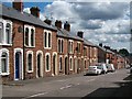
Terraced housing in Woodvale Street, off the Shankill
Image: © Eric Jones
Taken: 21 Jul 2014
0.07 miles
2
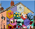
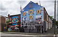
Playground mural, Belfast
A mural, showing scenes from the world of nature, near the corner of Disraeli Street and Ohio Street.
Image: © Albert Bridge
Taken: 12 Nov 2013
0.07 miles
3
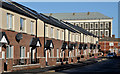
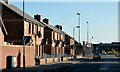
Disraeli Street, Belfast
Disraeli Street presents an interesting example of the growth of Belfast in the late 19th century. In 1877 it had 18 houses off the Crumlin Road. In 1890 there were 51. They increased to more than 160 by 1901 when it extended south to Woodvale Street. This is the recently rebuilt western side, seen from Ohio Street close to Leopold Street Image It now turns left and no longer runs through to the Crumlin Road. For reference purposes the former Brookfield Mill Image is at top right.
Image: © Albert Bridge
Taken: 12 Nov 2013
0.09 miles
4
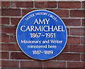
Amy Carmichael plaque, Belfast
See Image Very few people are honoured or commemorated by having two blue plaques. Amy Carmichael http://www.christianvoice.org.uk/index.php/heroes-of-faith/ and http://www.ulsterhistory.co.uk/carmichael.htm is one. This plaque is on the Heather Street side of the Welcome Evangelical church, at the corner of Cambrai Street.
Image: © Albert Bridge
Taken: 12 Nov 2013
0.10 miles
5
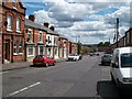
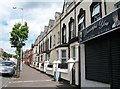
Bray Street in the Greater Shankill
This is an area of Victorian terraced housing built in what then used to be the outskirts of 19thC Belfast.
Image: © Eric Jones
Taken: 21 Jul 2014
0.11 miles
6
The lower end of Enfield Street, Woodvale
Image: © Eric Jones
Taken: 21 Jul 2014
0.13 miles
7
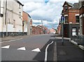
Leopold Street, Belfast
Leopold Street dates from before 1861 and once ran from Yew Street (close to the Shankill Road), across Ohio Street, to the Crumlin Road. Today’s rebuilt version is now a short cul-de-sac from Ohio Street (behind me). This is the western side.
Image: © Albert Bridge
Taken: 12 Nov 2013
0.13 miles
8
Paramilitary mural, Belfast
Loyalist paramilitary mural on a gable wall at the corner of Enfield and Disraeli streets in Belfast. These are still very common in many areas of both Belfast and Northern Ireland generally. It is in close proximity to Image
Image: © Rossographer
Taken: 16 Jun 2021
0.14 miles
9
Victorian houses in Woodvale Road, Greater Shankill
Image: © Eric Jones
Taken: 21 Jul 2014
0.14 miles
10
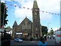
Woodvale Presbyterian Church
Opened in 1899 - it stands on the corner of the Woodvale Road and the Ballygomartin Road. Some of the congregation are making the best of some of the sunniest weather of Summer 2009 - rare indeed - their tea party outside wasn't hampered by typical Belfast showers.
Image: © Dean Molyneaux
Taken: 25 Aug 2009
0.14 miles