IMAGES TAKEN NEAR TO
Stanhope Street, BELFAST, BT13 1BB
Introduction
This page details the photographs taken nearby to Stanhope Street, BT13 1BB by members of the Geograph project.
The Geograph project started in 2005 with the aim of publishing, organising and preserving representative images for every square kilometre of Great Britain, Ireland and the Isle of Man.

There are currently over 7.5m images from over14,400 individuals and you can help contribute to the project by visiting https://www.geograph.org.uk
Image Map
Images are licensed for reuse under creativecommons.org/licenses/by-sa/2.0
Notes
- Clicking on the map will re-center to the selected point.
- The higher the marker number, the further away the image location is from the centre of the postcode.
Image Listing (449 Images Found)
Images are licensed for reuse under creativecommons.org/licenses/by-sa/2.0
Image
Details
Distance
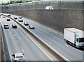
1
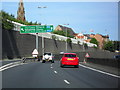
Westlink at Clifton Street
The A12 Westlink (Belfast's principal throughpass) here passes Clifton Street. Leaving here is recommended for the lower Antrim Road, Carlisle Circus and the Crumlin Road.
Image: © Dean Molyneaux
Taken: 12 Sep 2009
0.04 miles
2
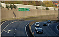
The Westlink, Belfast (4)
See Image The view towards the M2 and Clifton Street from the flyover at Peter’s Hill. Note the absence of goods vehicles on a Sunday morning. The northbound carriageway (left) was closed from Divis Street. Continue to Image
Image: © Albert Bridge
Taken: 15 Nov 2009
0.04 miles
3
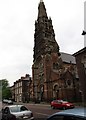
St Patrick's Catholic Church, Donegall Street
St Patrick's Church dates from 1874. It was here that the funeral mass for the comedian Frank Carson was held in March 2012. The church was in the news again on the 12th of July when sectarian music is said to have been played outside the chapel by an Orange band.http://www.belfasttelegraph.co.uk/news/local-national/northern-ireland/fury-at-loyalist-bands-musical-taunts-outside-catholic-church-16184986.html
Image: © Eric Jones
Taken: 20 May 2012
0.08 miles
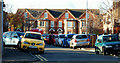
4
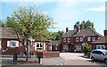
Houses on the east side of Denmark Street
Image: © Eric Jones
Taken: 10 Jul 2015
0.09 miles
5
Tyrone Street, Belfast
Tyrone Street/Sraid Thir Eoghain and Wall Street/Sraid An Bhalla (background) are both streets in a redeveloped area off Carrick Hill/Cnoc na Carraige Image For those who like to record such things, the townland is Town Parks. See also Image
Image: © Albert Bridge
Taken: 10 Nov 2009
0.09 miles
6
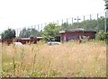
Waste ground at the junction of Clifton Street and Stanhope Street
The tall wire fence protects traffic on the Westlink from missile attacks.
Image: © Eric Jones
Taken: 10 Jul 2015
0.09 miles
7
View south-west along the A12 (Westlink) from the Clifton Street bridge
Image: © Eric Jones
Taken: 10 Jul 2015
0.09 miles
8

Belfast: Clifton Street Orange Hall (rooftop detail)
A close-up of the roof of Image, looking into the morning sun. Coils of barbed wire can be discerned right of picture.
Image: © Chris Downer
Taken: 12 Nov 2007
0.10 miles
9
The Growing Garden in Denmark Street
This is a lower Shankill community development iniative whereby vacant land in Denmark Street near the interface fence has been converted into gardening space. The project includes the providion of an outdoor classroom, community growing strips and informal play areas.
http://www.newsletter.co.uk/news/regional/fruit-and-veg-to-replace-eyesore-1-5941019
Image: © Eric Jones
Taken: 10 Jul 2015
0.10 miles
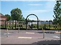
10
New housing in the Carrick Hill area
This area blighted by The Troubles has been redeveloped in recent years.
Image: © Eric Jones
Taken: 20 May 2012
0.10 miles