IMAGES TAKEN NEAR TO
Plunkett Court, BELFAST, BT13 1AZ
Introduction
This page details the photographs taken nearby to Plunkett Court, BT13 1AZ by members of the Geograph project.
The Geograph project started in 2005 with the aim of publishing, organising and preserving representative images for every square kilometre of Great Britain, Ireland and the Isle of Man.

There are currently over 7.5m images from over14,400 individuals and you can help contribute to the project by visiting https://www.geograph.org.uk
Image Map
Images are licensed for reuse under creativecommons.org/licenses/by-sa/2.0
Notes
- Clicking on the map will re-center to the selected point.
- The higher the marker number, the further away the image location is from the centre of the postcode.
Image Listing (1221 Images Found)
Images are licensed for reuse under creativecommons.org/licenses/by-sa/2.0
Image
Details
Distance
1
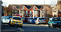
Tyrone Street, Belfast
Tyrone Street/Sraid Thir Eoghain and Wall Street/Sraid An Bhalla (background) are both streets in a redeveloped area off Carrick Hill/Cnoc na Carraige Image For those who like to record such things, the townland is Town Parks. See also Image
Image: © Albert Bridge
Taken: 10 Nov 2009
0.02 miles
2
New housing in the Carrick Hill area
This area blighted by The Troubles has been redeveloped in recent years.
Image: © Eric Jones
Taken: 20 May 2012
0.04 miles
3
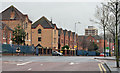
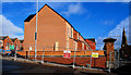
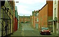
Houses, Carrick Hill, Belfast
Modern social housing, on the western side of Carrick Hill, built on the site of the short-lived Unity Flats. Carrick Hill was previously known as Upper Library Street and, originally, Carrick Hill. This photograph appears as a matter of neutral geographical record only and does not express any political or sectarian opinion.
Image: © Albert Bridge
Taken: 18 Dec 2013
0.05 miles
4
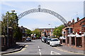
Arch, Carrick Hill, Belfast
Pictured along Carrick Hill
Image: © Kenneth Allen
Taken: 14 May 2019
0.05 miles
5
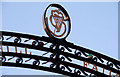
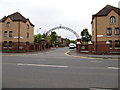
Ornamental arch, Belfast
Part of a recently-erected arch across the entrance to Tyrone Street/Sraid Thir Eoghain Image The residents are very pleased with it but less so with those who found it necessary to insert the two balls in the line below the crest.
Image: © Albert Bridge
Taken: 10 Nov 2009
0.05 miles
6
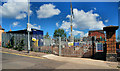
New housing site, Carrick Hill, Belfast (2)
See Image Today’s view of the site (closed for the trade holidays) with some houses under construction in the background. This Image is behind the pillar on the right.
Image: © Albert Bridge
Taken: 23 Jul 2010
0.06 miles
7
New housing site, Carrick Hill, Belfast (3)
See Image In the seven months since the previous photograph the houses have reached the stage where they seem to be nearing completion.
Image: © Albert Bridge
Taken: 13 Feb 2011
0.06 miles
8
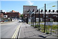
Library Street, Belfast
Heading ESE from Carrick Hill
Image: © Kenneth Allen
Taken: 14 May 2019
0.07 miles
9
Carrick Hill, Belfast (November 2015)
Carrick Hill at the corner of Clifton Street – an area included in the Northview redevelopment proposals.
Image: © Albert Bridge
Taken: 1 Nov 2015
0.07 miles
10
Kent Street, Belfast (2)
Image: © Albert Bridge
Taken: 8 Jan 2009
0.07 miles