IMAGES TAKEN NEAR TO
Waring Street, BELFAST, BT1 2EW
Introduction
This page details the photographs taken nearby to Waring Street, BT1 2EW by members of the Geograph project.
The Geograph project started in 2005 with the aim of publishing, organising and preserving representative images for every square kilometre of Great Britain, Ireland and the Isle of Man.

There are currently over 7.5m images from over14,400 individuals and you can help contribute to the project by visiting https://www.geograph.org.uk
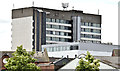
Image Map
Images are licensed for reuse under creativecommons.org/licenses/by-sa/2.0
Notes
- Clicking on the map will re-center to the selected point.
- The higher the marker number, the further away the image location is from the centre of the postcode.
Image Listing (3472 Images Found)
Images are licensed for reuse under creativecommons.org/licenses/by-sa/2.0
Image
Details
Distance
1
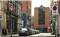
River House, Belfast - July 2017(2)
The back of the building, entirely covered by plastic sheeting, seen from Waring Street.
Image: © Albert Bridge
Taken: 10 Jul 2017
0.01 miles
2
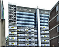
River House, Belfast - October 2017(1)
A back view, from Waring Street. Much of the plastic sheeting has been removed.
Image: © Albert Bridge
Taken: 28 Oct 2017
0.01 miles
3
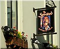
Bar sign, Belfast
Signs such as this one in Skipper Street Image are not indigenous in any part of Ireland. Not too common.
Image: © Albert Bridge
Taken: 11 May 2008
0.01 miles
4
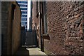
Sugarhouse Entry, Belfast
See Image Sugarhouse (also “Sugar House”) Entry takes its name from the sugar house established there in 1704. The entry later became better known for the “Dr Franklin Tavern” – home to “The Muddlers’ Club”. The entry was closed (using emergency legislation) as a precaution against bombs and is no longer a public thoroughfare. The view is from Waring Street to High Street. See also Image (February 2014).
Image: © Albert Bridge
Taken: 22 Jul 2007
0.01 miles
5
Skipper Street, Belfast
Skipper Street looking from Hill Street (incorrectly shown as Henry Street on the Google map) to High Street. In the mid 18th century, before the reclamation of land to the west of the Lagan, ships berthed very close to here. It is said that many captains (“skippers”) lived in the street. For a later view, after environmental improvements, see Image
Image: © Albert Bridge
Taken: 13 Apr 2008
0.02 miles
6
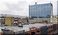
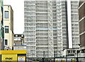
River House, Belfast
Elevated view of River House on High Street, Belfast; the top deck of the InShops/Hi-Park multi-storey car park is in the foreground.
Image: © Rossographer
Taken: 27 Jan 2018
0.02 miles
7
The Waring Hotel, Belfast (December 2016)
Builder’s hoarding now erected around the site.
Image: © Albert Bridge
Taken: 13 Dec 2016
0.02 miles
8
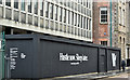
The Waring Hotel, Belfast (December 2017)
Work seems to have been suspended.
Image: © Albert Bridge
Taken: 3 Dec 2017
0.02 miles
9
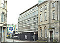
River House, Belfast (September 2007)
River House, in High Street, was built in the early 70’s. The land had been vacant since WWII when much of High Street was flattened by the Luftwaffe. This had been (I think) the last remaining Blitz site in central Belfast.
Image: © Albert Bridge
Taken: 30 Sep 2007
0.02 miles
10
River House, Belfast (June 2014)
The forgotten view of this office block – the back seen from the Dunbar Link/Corporation Street. It also shows how River House dominates the surrounding lower buildings.
Image: © Albert Bridge
Taken: 19 Jun 2014
0.02 miles