IMAGES TAKEN NEAR TO
Rockview Street, BELFAST, BT12 6JQ

Introduction

This page details the photographs taken nearby to Rockview Street, BT12 6JQ by members of the Geograph project.

The Geograph project started in 2005 with the aim of publishing, organising and preserving representative images for every square kilometre of Great Britain, Ireland and the Isle of Man.

There are currently over 7.5m images from over14,400 individuals and you can help contribute to the project by visiting https://www.geograph.org.uk

Image Map


Images are licensed for reuse under creativecommons.org/licenses/by-sa/2.0
Notes
  • Clicking on the map will re-center to the selected point.
  • The higher the marker number, the further away the image location is from the centre of the postcode.

Image Listing (214 Images Found)

Images are licensed for reuse under creativecommons.org/licenses/by-sa/2.0
  • ...
Image
Details
Distance
1
Tavanagh Street, Belfast
A street, between the Donegall Road (behind me) and Tate’s Avenue, built over a period at the turn of the 20th century. Some of the street (left) has been redeveloped.
Image: © Albert Bridge Taken: 8 Apr 2012
0.02 miles
2
Northern Ireland - Euro 2016 poster (Conor Washington), Belfast (June 2016)
Donegall Road near Rockview Street - Conor Washington https://en.wikipedia.org/wiki/Conor_Washington
Image: © Albert Bridge Taken: 7 Jun 2016
0.04 miles
3
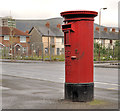
Pillar box, Belfast
EIIR pillar box, on the Donegall Road, between Kilburn Street and Rockview Street. Rockland Street Image is in the background. The notice plate is missing but the number should be BT12 324.
Image: © Albert Bridge Taken: 8 Apr 2012
0.04 miles
4
Benburb Street, Belfast (3)
See Image (August 2010). The Donegall Road end of Benburb Street which still has some of the original terrace houses.
Image: © Albert Bridge Taken: 8 Apr 2012
0.05 miles
5
Broadway, Belfast
Broadway was built, over a number of years in the late 19th century, running from the Falls Road via the Donegall Road to Donegall Avenue. The opening of the M1 roundabout, later enlarged for the Westlink and, later still, the Broadway underpass Image and Image severed it. This is the section of the street at Glenmachan Street (off the Donegall Road) looking towards Donegall Avenue. Image shows the same view in June 2011.
Image: © Albert Bridge Taken: 12 Aug 2009
0.05 miles
6
"EIIR" mural, Belfast
A mural, at the Broadway end of Rockview Street, showing the royal cypher and a portrait of the Queen - similar to that on postage stamps in the 1960’s.
Image: © Albert Bridge Taken: 23 May 2012
0.05 miles
7
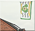
Northern Ireland football flag, Belfast (June 2016)
The Northern Ireland football flag flying at Lower Rockview Street.
Image: © Albert Bridge Taken: 7 Jun 2016
0.05 miles
8
Rockland Street, Belfast - February 2014 (2)
The eastern side of the new Rockland Street. Image shows the street, before demolition, in June 2011.
Image: © Albert Bridge Taken: 8 Feb 2014
0.06 miles
9
Lower Rockview Street, Belfast - February 2014
The new Lower Rockview Street. Image shows the street during demolition in June 2011.
Image: © Albert Bridge Taken: 8 Feb 2014
0.06 miles
10
Rockland Street, Belfast - February 2014 (1)
The western side of the new Rockland Street. Image shows the street, before demolition, in June 2011.
Image: © Albert Bridge Taken: 8 Feb 2014
0.06 miles
  • ...