IMAGES TAKEN NEAR TO
Blythe Street, BELFAST, BT12 5HU
Introduction
This page details the photographs taken nearby to Blythe Street, BT12 5HU by members of the Geograph project.
The Geograph project started in 2005 with the aim of publishing, organising and preserving representative images for every square kilometre of Great Britain, Ireland and the Isle of Man.

There are currently over 7.5m images from over14,400 individuals and you can help contribute to the project by visiting https://www.geograph.org.uk
Image Map
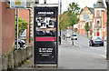
Images are licensed for reuse under creativecommons.org/licenses/by-sa/2.0
Notes
- Clicking on the map will re-center to the selected point.
- The higher the marker number, the further away the image location is from the centre of the postcode.
Image Listing (866 Images Found)
Images are licensed for reuse under creativecommons.org/licenses/by-sa/2.0
Image
Details
Distance
1
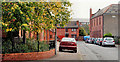
Eureka Drive, Belfast (2)
See Image The view in the other direction, towards Tierney Gardens, with the trees showing the signs of autumn.
Image: © Albert Bridge
Taken: 24 Sep 2010
0.04 miles
2
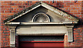
St Aidan's church hall, Belfast (detail) (1)
St Aidan’s (CoI) church is in Blythe Street (off Sandy Row) but the hall is on the Donegall Road at the corner of Tierney Gardens. This pediment is on the Tierney Gardens side. Continue to Image
Image: © Albert Bridge
Taken: 26 Nov 2009
0.04 miles
3
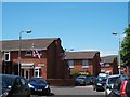
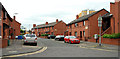
Aughrim Park, Sandy Row
This is a residential area behind the main street of Sandy Row.
Image: © Eric Jones
Taken: 30 Jun 2015
0.05 miles
4
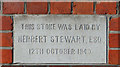
St Aidan's church hall, Belfast (detail) (2)
See Image This foundation stone also faces Tierney Gardens. The date is interesting in view of the wartime restrictions on building materials in non-essential work.
Image: © Albert Bridge
Taken: 26 Nov 2009
0.05 miles
5
Matilda Drive, Belfast
Redeveloped street between Sandy Row and the Donegall Road. If my memory is correct, then it’s approximately on the site of Primitive Street which had, I think, a Methodist church at the Donegall Road end.
Image: © Albert Bridge
Taken: 18 Jun 2010
0.05 miles
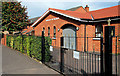
6
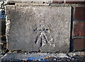
Bench Mark, Belfast
Cut bench mark located on the extreme south-western edge of a hall on the Donegall Road at the junction with Roseland Place.
See also http://www.geograph.org.uk/search.php?i=11037856 for many other examples I have found.
Image: © Rossographer
Taken: 4 Mar 2010
0.05 miles
7
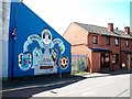
The Robert Dougan Plaque and Mural in Blythe Street off Sandy Row
Robert Dougan (38) was a member of the Loyalist UDA who was shot by the IRA in February, 1998 while sitting in his car outside Balmoral Textiles Ltd, Dunmurry in the west of the city.
Image: © Eric Jones
Taken: 30 Jun 2015
0.06 miles
8
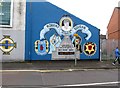
The Robert Dougan Memorial Mural, Blythe Street
Robert Dougan. a prominent member of the Loyalist paramilitary group, the Ulster Defence Association, was murdered by the IRA in 1998.
Image: © Eric Jones
Taken: 19 May 2012
0.06 miles
9
Telephone box, Donegall Road, Belfast (October 2016)
A KX100 telephone box between Blondin and Gaffikin Streets.
Image: © Albert Bridge
Taken: 2 Oct 2016
0.06 miles
10
Church of the Nazarene, Belfast
There are more than 90 such churches in the UK. This one is just off the Donegall Road, at Roseland Place.
Image: © Albert Bridge
Taken: 24 Sep 2010
0.06 miles