IMAGES TAKEN NEAR TO
Devonshire Close, BELFAST, BT12 4JS
Introduction
This page details the photographs taken nearby to Devonshire Close, BT12 4JS by members of the Geograph project.
The Geograph project started in 2005 with the aim of publishing, organising and preserving representative images for every square kilometre of Great Britain, Ireland and the Isle of Man.

There are currently over 7.5m images from over14,400 individuals and you can help contribute to the project by visiting https://www.geograph.org.uk
Image Map
Images are licensed for reuse under creativecommons.org/licenses/by-sa/2.0
Notes
- Clicking on the map will re-center to the selected point.
- The higher the marker number, the further away the image location is from the centre of the postcode.
Image Listing (172 Images Found)
Images are licensed for reuse under creativecommons.org/licenses/by-sa/2.0
Image
Details
Distance
1
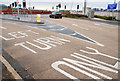
Westlink grass, Belfast
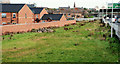
A grassed area between the houses off the Cullingtree Road (left) and the Westlink Image It came about after the replacement of the Grosvenor Road roundabout by a flyover Image The absence of landscaping could generate a conspiracy theory that it might become a northbound sliproad at some future date.
Image: © Albert Bridge
Taken: 24 Sep 2010
0.03 miles
2
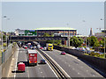
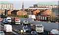
Belfast, Westlink (A12)
The Westlink road in Belfast, is a dual carriageway throughpass, designated the A12, connecting the M1 to the M2 and M3 motorways which run south, north and east of the city, respectively. This view is from Grosvenor Road.
Image: © David Dixon
Taken: 26 May 2017
0.05 miles
3

The Westlink, Belfast (12)
See Image The bridge across the Westlink has this well-designed fence. Whether it will deter the behaviourally different from the noble and ancient practice of dropping bricks and other objects on passing traffic is another matter.
Image: © Albert Bridge
Taken: 4 Feb 2008
0.05 miles
4
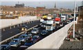
The Westlink, Belfast (9)
See Image Two lanes of the underpass are now open in each direction. The old temporary alignment of the Grosvenor Road is on the right although hardly recognisable. The scheme includes another underpass at Broadway on the Donegall Road and the widening of the Broadway – Stockman’s Lane section of the M1 to three lanes – while keeping the road open for all traffic. The overall completion date is currently given as March 2009. In the meantime queues such as this are common throughout the working day.
Image: © Albert Bridge
Taken: 4 Feb 2008
0.05 miles
5
The Westlink, Belfast (11)
See Image The temporary bridge Image carrying the Grosvenor Road across the Westlink has now been removed. The “new” Grosvenor Road is now open to traffic but there are lane restrictions pending completion of surfacing and other work. The view is outward.
Image: © Albert Bridge
Taken: 4 Feb 2008
0.05 miles
6
The Westlink, Belfast (5)
See Image The off-slip, at the Grosvenor Road, used by traffic from the M1 heading towards the Falls Road (left) and the city centre. Continue to Image
Image: © Albert Bridge
Taken: 18 Nov 2009
0.05 miles
7
The Westlink, Belfast (10)
See Image There is no southbound exit from the Westlink to the Grosvenor Road (and the city centre) here mainly because of the proximity of the houses in the background. The view is towards the M2.
Image: © Albert Bridge
Taken: 4 Feb 2008
0.06 miles
8
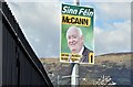
Assembly election poster, Grosvenor Road, Belfast - April 2016(1)
Grosvenor Road. Fra McCann, Pat Sheehan, Rosie McCorley, Jennifer McCann and Alex Maskey (Sinn Féin).
Image: © Albert Bridge
Taken: 17 Apr 2016
0.06 miles
9
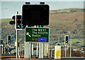
Westlink sign, Belfast
The slightly inconspicuous direction sign for the Westlink, at the Grosvenor Road underpass Image
Image: © Albert Bridge
Taken: 6 Dec 2009
0.07 miles
10
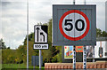
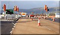
Variable speed-limit sign, Belfast
A variable speed limit (retaining the existing overall limit of 50) came into operation over the Westlink during the month. According to the official announcement “The implementation of this traffic control system on the A12 Westlink will be the first time that variable mandatory speed limits have been applied to a road here [ie Northern Ireland]. New legislation has been put in place to enable enforcement of the variable speed limits by the police. The speed limits will be recognisable as mandatory as there will be a red ring around the speed limit being displayed on the gantries.” This sign is at the southbound on-slip at the Grosvenor Road.
Image: © Albert Bridge
Taken: 24 Sep 2010
0.07 miles