IMAGES TAKEN NEAR TO
BS99 7PS
Introduction
This page details the photographs taken nearby to BS99 7PS by members of the Geograph project.
The Geograph project started in 2005 with the aim of publishing, organising and preserving representative images for every square kilometre of Great Britain, Ireland and the Isle of Man.

There are currently over 7.5m images from over14,400 individuals and you can help contribute to the project by visiting https://www.geograph.org.uk
Image Map
Images are licensed for reuse under creativecommons.org/licenses/by-sa/2.0
Notes
- Clicking on the map will re-center to the selected point.
- The higher the marker number, the further away the image location is from the centre of the postcode.
Image Listing (79 Images Found)
Images are licensed for reuse under creativecommons.org/licenses/by-sa/2.0
Image
Details
Distance
1
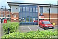
East Central Delivery Office
City Business Park
Image: © Anthony O'Neil
Taken: 18 Aug 2021
0.01 miles
2
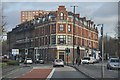
Bristol : Clarence Road
Clarence Road which is about to split into two at the building used for YMCA training.
Image: © Lewis Clarke
Taken: 1 Feb 2013
0.06 miles
3
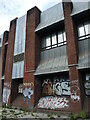
Clarence Road telephone exchange
The exchange used to occupy a smaller site just a very short distance away before moving here. The uncommon architecture is no defence against the tide of paint, though.
Image: © Neil Owen
Taken: 5 May 2022
0.06 miles
4
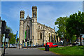
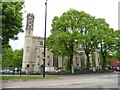
Holy Trinity, St Philip's
Now an arts centre, Holy Trinity is a Late Georgian Commissioners' gothic essay by Thomas Rickman, the man whose terminology to define the gothic is still in use today. 'Characteristically Perpendicular' says Pevsner, to emphasise that point. Built in Bath stone at a huge cost of £ 8,231 and completed in 1832, 5 years before Victoria came to the throne.
Image: © Philip Pankhurst
Taken: 12 May 2016
0.08 miles
6
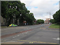
Clarence Road
With a speeding police car.
Image: © Stephen Craven
Taken: 24 Jun 2017
0.09 miles
7
From prayer to performance
Holy Trinity was consecrated on 17th February, 1832. It served the growing local population in what became a relatively poor working class area. As time went by, the congregation dwindled and the authorities released the church in the 1960s. It then became used, on and off, as a community venue for local groups. Often the church building fell back into dereliction before reopening again.
Today it is a music and arts venue and has remained open for a couple of decades; it even has received a licence to perform civil ceremonies and now can hold weddings once again!
A bolt benchmark is just visible at the foot of the nearest bell tower - see Image
Image: © Neil Owen
Taken: 5 May 2022
0.09 miles
8
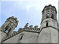
Twin belfries
Holy Trinity church was partly funded after the defeat of Napoleon and architects Thomas Rickman and Henry Hutchinson were employed to design it. They used a Perpendicular style in creating two open octagonal bell towers on the west end, which lack bells now that the church has been decommissioned and has become an arts centre.
Image: © Neil Owen
Taken: 5 May 2022
0.09 miles
9
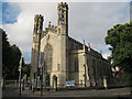
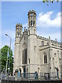
Trinity Arts Centre, Trinity Road
The former Holy Trinity church, built 1829-32 architects Thomas Rickman and Hutchinson. It is now a community arts centre, but still listed grade 2* (list entry 1282076).
Image: © Stephen Craven
Taken: 24 Jun 2017
0.09 miles
10
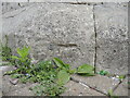
Bolt benchmark on the old Holy Trinity
The church dates from 1832 and the west end has a bolt benchmark that is just about visible today. Not only has the modern ground level risen thanks to the paviers, the stonework is crumbling so badly that the chisel marks are weathered. See https://www.bench-marks.org.uk/bm28912 for the entry in the Benchmark Database and Image] for a wider view.
Image: © Neil Owen
Taken: 5 May 2022
0.10 miles