IMAGES TAKEN NEAR TO
Southwood Drive, BRISTOL, BS9 2QR
Introduction
This page details the photographs taken nearby to Southwood Drive, BS9 2QR by members of the Geograph project.
The Geograph project started in 2005 with the aim of publishing, organising and preserving representative images for every square kilometre of Great Britain, Ireland and the Isle of Man.

There are currently over 7.5m images from over14,400 individuals and you can help contribute to the project by visiting https://www.geograph.org.uk
Image Map
Images are licensed for reuse under creativecommons.org/licenses/by-sa/2.0
Notes
- Clicking on the map will re-center to the selected point.
- The higher the marker number, the further away the image location is from the centre of the postcode.
Image Listing (19 Images Found)
Images are licensed for reuse under creativecommons.org/licenses/by-sa/2.0
Image
Details
Distance
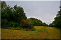
1
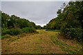
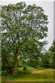
Henbury : Grassy Field
A right of way heads across Kings Weston Hill.
Image: © Lewis Clarke
Taken: 8 Sep 2020
0.09 miles
2
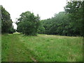
Kings Weston Hill
The top of this hill is kept as a long narrow strip of grassland which is a nature reserve.
Image: © don cload
Taken: 8 Aug 2012
0.12 miles
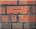
3
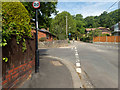
The way up on to Kings Weston Hill
Ahead is a track leading from the road that takes one up onto the ridge leading south west to Kings Weston Hill. There is a cut benchmark Image on the wall behind the lamppost on the left.
Image: © Neville Goodman
Taken: 17 May 2020
0.14 miles
4
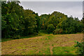
Henbury : Grassy Field
A field on top of Kings Weston Hill.
Image: © Lewis Clarke
Taken: 8 Sep 2020
0.15 miles
5
Henbury Grassy Field
A right of way heads across Kings Weston Hill.
Image: © Lewis Clarke
Taken: 8 Sep 2020
0.15 miles
6
Damaged benchmark on a house
This cut benchmark in Grove Road Image (OS description: NE FACE WALL NO57 GROVE RD) has been damaged at some time, perhaps when the wall was repointed.
Image: © Neville Goodman
Taken: 17 May 2020
0.16 miles
7
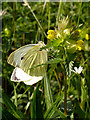
Large White Butterfly on Hay Rattle
Growing in the grass meadow on Kings Weston Hill. Apparently the common name of Hay Rattle (Rhinanthus minor) refers to the noise made by the dry seed case when it is time to harvest the hay. It is also known as Yellow Rattle.
View of the grassland Image
Image: © Linda Bailey
Taken: 29 May 2006
0.16 miles
8
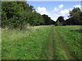
Path on King Weston Hill
Heading towards Blaise Castle
Image: © Eirian Evans
Taken: 19 Sep 2017
0.16 miles
9
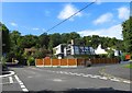
In the Depths of Coombe Dingle
Some individual styles of houses on the edge of this suburb.
Image: © Colin Bews
Taken: 26 Jul 2011
0.16 miles
10
Henbury : Grassy Field
A right of way heads through the field.
Image: © Lewis Clarke
Taken: 8 Sep 2020
0.18 miles