IMAGES TAKEN NEAR TO
Romney Avenue, BRISTOL, BS7 9TG
Introduction
This page details the photographs taken nearby to Romney Avenue, BS7 9TG by members of the Geograph project.
The Geograph project started in 2005 with the aim of publishing, organising and preserving representative images for every square kilometre of Great Britain, Ireland and the Isle of Man.

There are currently over 7.5m images from over14,400 individuals and you can help contribute to the project by visiting https://www.geograph.org.uk
Image Map (Loading...)


Getting Data...Please wait
Leaflet Map data © OpenStreetMap
Images are licensed for reuse under creativecommons.org/licenses/by-sa/2.0
Notes
- Clicking on the map will re-center to the selected point.
- The higher the marker number, the further away the image location is from the centre of the postcode.
Image Listing (64 Images Found)
Images are licensed for reuse under creativecommons.org/licenses/by-sa/2.0
Image
Details
Distance
1
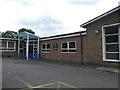
Entrance to Stoke Park Primary School and Nursery, Bristol
Viewed across Romney Avenue. The name board shows Stoke Park Schools and Stoke Park Nursery.
The recently-built schools occupy the site of the former Lockleaze Primary School and Early Years Centre.
Image: © Jaggery
Taken: 29 Dec 2013
0.02 miles
2
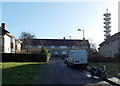
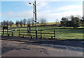
Rackham Close, Bristol
Rackham Close is a 70 metre long cul-de-sac on the SE side of Romney Avenue.
Visible from a wide area, a communications tower on Pur Down is in the background.
Image: © Jaggery
Taken: 29 Dec 2013
0.04 miles
3
Mulready Close, Bristol BS7
A 70 metre long cul-de-sac on the SE side of Romney Avenue.
Image: © Jaggery
Taken: 29 Dec 2013
0.06 miles
4
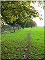
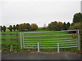
Field edge boundary
Pur Down playing fields at Lockleaze.
Image: © Dr Duncan Pepper
Taken: 26 Oct 2008
0.06 miles
6
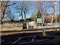
Romney Avenue entrance to the Stoke Park Estate, Bristol
The welcome board at the entrance on the left states that Stoke Park Estate is a Grade II listed historic parkland, owned and managed by Bristol City Council.
Image: © Jaggery
Taken: 29 Dec 2013
0.08 miles
7
Entrance gate to Pur Down, near Mulready Close in Romney Avenue
Image: © Dr Duncan Pepper
Taken: 26 Oct 2008
0.08 miles
8
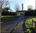
Gilray Close, Bristol
Gilray Close is a 70 metre long cul-de-sac on the SE side of Romney Avenue.
Visible from a wide area, a telecommunications tower on Pur Down is in the background.
Image: © Jaggery
Taken: 29 Dec 2013
0.08 miles
9
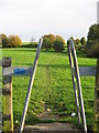
A modern stile at Lockleaze playing fields
Originally designed to allow the passage of humans whilst holding back cattle, this simple but elegant design now discourages motorcyclists from using the playing fields.
Image: © Dr Duncan Pepper
Taken: 26 Oct 2008
0.08 miles
10
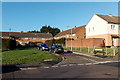
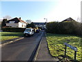
Stanfield Close, Lockleaze, Bristol
Viewed across Romney Avenue from the edge of the Stoke Park Estate.
Image: © Jaggery
Taken: 29 Dec 2013
0.09 miles