IMAGES TAKEN NEAR TO
Allfoxton Road, BRISTOL, BS7 9NJ
Introduction
This page details the photographs taken nearby to Allfoxton Road, BS7 9NJ by members of the Geograph project.
The Geograph project started in 2005 with the aim of publishing, organising and preserving representative images for every square kilometre of Great Britain, Ireland and the Isle of Man.

There are currently over 7.5m images from over14,400 individuals and you can help contribute to the project by visiting https://www.geograph.org.uk
Image Map
Images are licensed for reuse under creativecommons.org/licenses/by-sa/2.0
Notes
- Clicking on the map will re-center to the selected point.
- The higher the marker number, the further away the image location is from the centre of the postcode.
Image Listing (43 Images Found)
Images are licensed for reuse under creativecommons.org/licenses/by-sa/2.0
Image
Details
Distance
1
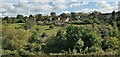
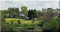
Across Boiling Wells
Houses on Stottbury Road, and the modern Fairfield High School behind
Image: © Chris Morgan
Taken: 25 Sep 2020
0.07 miles
2
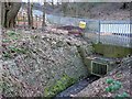
Boiling Wells Brook
This brook runs through the valley of Ashley Vale. At one time the water was piped from here to the city centre in Quay Pipe to a water fountain on the quayside at the Stone Bridge, formerly called St Giles' Bridge, which was the highest point of the Frome navigable by the Severn trows and was known as Quay Head. It was called boiling because of its bubbling nature and not because of its temperature. In the background is the Boiling Wells site of St Werburghs City Farm. This is under construction and will provide an open air amphitheatre.
Image: © Nigel Mykura
Taken: 7 Feb 2010
0.09 miles
3
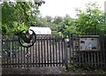
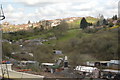
City Farm Boiling Wells Project
Boiling Wells is a 2.5 acre site nestled in a tranquil woodland valley just three minutes walk from the main Farm site. With wild green spaces, a terraced orchard interspersed with rambling soft fruit, native trees and a nearby stream, it is a unique oasis in the heart of the city. A range of outdoor activities are run throughout the week that are not easily accessed elsewhere within the city, often supporting vulnerable children and adults. It can also be hired for green weddings.
Image: © Eirian Evans
Taken: 21 Sep 2017
0.11 miles
4
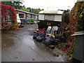
Ennywevers Campsite, Boiling Well's Lane
Bristol's only camping and glamping site - "rural camping in the heart of Bristol". There is a field for tents, a barbecue area and woodburning oven.
Image: © Eirian Evans
Taken: 21 Sep 2017
0.11 miles
5
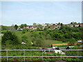
Across the railway line, Ashley Vale
From footpath BCC 209/10, with houses on Stottbury Road, and the modern Fairfield High School behind to the right. Mostly hidden in the foreground is Watercress Farm; "the pure waters of the Boiling Wells grew fine watercress as a commercial crop" https://adriankerton.wordpress.com/bristols-boiling-wells-and-quay-pipe/ .
Image: © Derek Harper
Taken: 7 May 2019
0.12 miles
6
Sheds and temporary buildings off Boiling Wells Lane, Bristol
Image: © Roy Hughes
Taken: 30 Apr 2022
0.13 miles
9
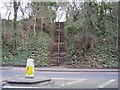
Footpath steps off Muller Road
Areas of green still exist in the heart of the city.
Image: © Anthony Vosper
Taken: 17 Mar 2012
0.14 miles
10
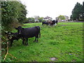
Unexpected cattle
Belonging to Watercress Farm, Boiling Well Lane. I was surprised to see cattle in the city suburbs.
Image: © Eirian Evans
Taken: 21 Sep 2017
0.14 miles