IMAGES TAKEN NEAR TO
Ashgrove Avenue, BRISTOL, BS7 9LL
Introduction
This page details the photographs taken nearby to Ashgrove Avenue, BS7 9LL by members of the Geograph project.
The Geograph project started in 2005 with the aim of publishing, organising and preserving representative images for every square kilometre of Great Britain, Ireland and the Isle of Man.

There are currently over 7.5m images from over14,400 individuals and you can help contribute to the project by visiting https://www.geograph.org.uk
Image Map
Images are licensed for reuse under creativecommons.org/licenses/by-sa/2.0
Notes
- Clicking on the map will re-center to the selected point.
- The higher the marker number, the further away the image location is from the centre of the postcode.
Image Listing (85 Images Found)
Images are licensed for reuse under creativecommons.org/licenses/by-sa/2.0
Image
Details
Distance
1
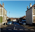
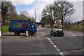
Talgarth Road, Ashley Down, Bristol
Viewed across Ashley Down Road looking along Talgarth Road towards Ashgrove Road.
Image: © Jaggery
Taken: 29 Dec 2013
0.05 miles
2
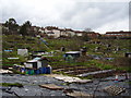
Muller Road Allotments
Early spring and some of the plots have been dug over.
Whilst the allotment holder in the foreground has chosen a less conventional way to suppress the weeds.
Image: © Anthony Vosper
Taken: 17 Mar 2012
0.07 miles
3
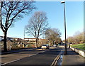
Muller Road, Bristol
The B4469 Muller Road heads NW away from a railway overbridge. Allotments are on the left.
Image: © Jaggery
Taken: 29 Dec 2013
0.07 miles
4
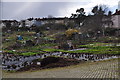
Bristol : Ashley Down Allotments
This is a well known site, easily visible from Muller Road. The site has both sloping and level plots, and has a water supply. There is water supply and water troughs. The site also has compost bays where council leaves are delivered for tenants use each autumn, and has communal orchard plots.
Image: © Lewis Clarke
Taken: 24 Mar 2015
0.07 miles
5
Bristol : Muller Road B4469
Muller Road at the road junction with Petherbridge Way.
Image: © Lewis Clarke
Taken: 24 Mar 2015
0.08 miles
6
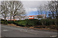
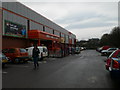
Bristol : Petherbridge Way
Petherbridge Way with the B&Q in view.
Image: © Lewis Clarke
Taken: 24 Mar 2015
0.08 miles
7
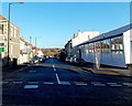
Ralph Road, Bristol
Viewed across Ashley Down Road. Brookfield Garage http://www.geograph.org.uk/photo/3945681 is on the right.
Image: © Jaggery
Taken: 29 Dec 2013
0.09 miles
8
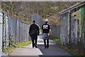
Bristol : Footpath
A footpath heading between Muller Road and Stoney Lane.
Image: © Lewis Clarke
Taken: 24 Mar 2015
0.09 miles
10
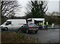
Bargain butties!
Very popular bacon bap joint outside B&Q in Ashley Down.
Image: © Eirian Evans
Taken: 24 Mar 2010
0.10 miles