1
Benchmark on gatepost of #72 Church Road
Ordnance Survey cut mark benchmark described on the Bench Mark Database at http://www.bench-marks.org.uk/bm27964.
Image: © Roger Templeman
Taken: 14 Aug 2010
0.02 miles
2
Ordnance Survey Cut Mark
This OS cut mark can be found on the wall between Nos 70 & 72 Church Road. It marks a point 73.143m above mean sea level.
Image: © Adrian Dust
Taken: 1 Jul 2022
0.02 miles
3
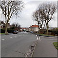
Church Road, Horfield, Bristol
Church Road descends away from Wellington Hill past the left turn for Churchways Avenue
Image: © Jaggery
Taken: 30 Jan 2013
0.02 miles
4
Wellington Hill
From near the top of Wellington Hill, looking south-east, the trees are pruned as they are in many parts of Bristol. In the distance, through the trees, is Purdown dusted with snow.
Image: © Linda Bailey
Taken: 28 Feb 2006
0.05 miles
5
Churchways Avenue, Horfield, Bristol
Viewed across Gloucester Road past Horfield Methodist Church http://www.geograph.org.uk/photo/4015442 on the right.
A sign on the right points along Churchways Avenue towards the Henleaze area of Bristol.
Image: © Jaggery
Taken: 29 Dec 2013
0.06 miles
6
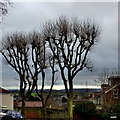
Trees at the junction of Wellington Road and Church Road
Image: © Robert Eva
Taken: 25 Dec 2016
0.06 miles
7
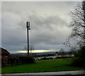
Wellington Hill playing field
Goalposts and phone mast
Image: © Robert Eva
Taken: 25 Dec 2016
0.08 miles
8
Horfield Parish Church Hall, Bristol
On the corner of Church Road and Wellington Hill, on the south side of the parish church. http://www.geograph.org.uk/photo/3367021
Image: © Jaggery
Taken: 30 Jan 2013
0.08 miles
9
Wellington Hill, Horfield, Bristol
Wellington Hill descends towards the A38 Gloucester Road, past the Church Road junction on the right.
Image: © Jaggery
Taken: 30 Jan 2013
0.09 miles
10
Benchmark on Horfield Parish Church Hall, Wellington Hill
Ordnance Survey cut mark benchmark described on the Bench Mark Database at http://www.bench-marks.org.uk/bm27965.
Image: © Roger Templeman
Taken: 14 Aug 2010
0.09 miles


