IMAGES TAKEN NEAR TO
Maple Road, BRISTOL, BS7 8RE
Introduction
This page details the photographs taken nearby to Maple Road, BS7 8RE by members of the Geograph project.
The Geograph project started in 2005 with the aim of publishing, organising and preserving representative images for every square kilometre of Great Britain, Ireland and the Isle of Man.

There are currently over 7.5m images from over14,400 individuals and you can help contribute to the project by visiting https://www.geograph.org.uk
Image Map
Images are licensed for reuse under creativecommons.org/licenses/by-sa/2.0
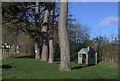
Notes
- Clicking on the map will re-center to the selected point.
- The higher the marker number, the further away the image location is from the centre of the postcode.
Image Listing (86 Images Found)
Images are licensed for reuse under creativecommons.org/licenses/by-sa/2.0
Image
Details
Distance
1
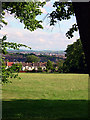
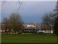
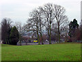
Horfield Common looking over Bristol
From Horfield Common it is possible to look over the centre of the city and out to the hills on the other side.
Image: © Linda Bailey
Taken: 7 Jul 2006
0.07 miles
2
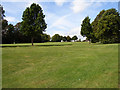
Horfield Common looking towards Kellaway Avenue
Standing near the bottom of the hill looking up (and across a grid line which is nearly at the top) towards Kellaway Avenue which runs along the top. The tennis courts are behind the line of trees on the left.
Image: © Linda Bailey
Taken: 13 Sep 2006
0.07 miles
4
Horfield Common
Looking out of the grid square from Kellaway Avenue, towards the south-east (the base of the common is GR ST591763). The white building in the centre of the photograph is the new Fairfield High School site at Grid Ref ST604754.
Image: © Linda Bailey
Taken: 16 Feb 2006
0.10 miles
5
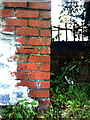
Benchmark(s) on wall on east side of Horfield Common
Ordnance Survey cut mark benchmark (or two) described on the Bench Mark Database at http://www.bench-marks.org.uk/bm30642.
Image: © Roger Templeman
Taken: 14 Aug 2010
0.10 miles
6
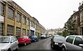
Elm Road Garage, Horfield
In an old works opposite terraced houses. At the end is the junction with Maple Road.
Image: © Derek Harper
Taken: 22 Apr 2014
0.11 miles
7
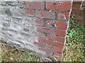
Ordnance Survey Cut Mark
This OS cut mark can be found on the wall east side of Horfield Common. It marks a point 77.623m above mean sea level.
Image: © Adrian Dust
Taken: 1 Jul 2022
0.12 miles
8
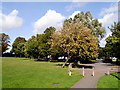
Ardagh Tennis Courts
On Horfield Common are the Ardagh Tennis Courts and Bowling Green. The Ardagh was a house on the common which was demolished in 1926.
Image: © Linda Bailey
Taken: 23 Dec 2005
0.12 miles
9
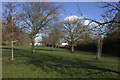
Ardagh Tennis Courts Car Park
The car park for the tennis courts and the access road leading up to Kellaway Avenue, lined by trees..
Image: © Linda Bailey
Taken: 19 Sep 2006
0.12 miles