IMAGES TAKEN NEAR TO
Horfield Common, BRISTOL, BS7 0XJ
Introduction
This page details the photographs taken nearby to Horfield Common, BS7 0XJ by members of the Geograph project.
The Geograph project started in 2005 with the aim of publishing, organising and preserving representative images for every square kilometre of Great Britain, Ireland and the Isle of Man.

There are currently over 7.5m images from over14,400 individuals and you can help contribute to the project by visiting https://www.geograph.org.uk
Image Map
Images are licensed for reuse under creativecommons.org/licenses/by-sa/2.0
Notes
- Clicking on the map will re-center to the selected point.
- The higher the marker number, the further away the image location is from the centre of the postcode.
Image Listing (92 Images Found)
Images are licensed for reuse under creativecommons.org/licenses/by-sa/2.0
Image
Details
Distance
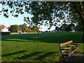
1

Horfield Common
Some frisbee fun in the late September sun on Bristol's ancient common. Mentioned in the Domesday Book (as Horefelle), it has yielded small Roman and Iron Age relics, although was probably forested for much of its history.
Image: © Neil Owen
Taken: 25 Sep 2010
0.01 miles
2
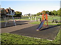
Children's play area
Horfield Common, Bristol. Just at the far end of the common (with its arched roof) is the sports centre, within whose bounds is a skateboard park for the slightly older children.
Image: © Neil Owen
Taken: 25 Sep 2010
0.02 miles
4
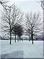
Avenue of small trees along a path
Path crossing part of the common leading to the Manor Farm Estate.
Image: © Linda Bailey
Taken: 12 Mar 2006
0.05 miles
5
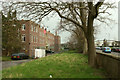
Army Reserve Centre, Horfield
Facing Horfield Common across Bishopsthorpe Road. Away on the right is Horfield Leisure Centre.
Image: © Derek Harper
Taken: 7 Mar 2020
0.05 miles
6
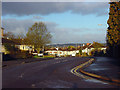
Bishopthorpe Road, Bishop Manor Estate
Looking west down Bishopthorpe Road, into the Bishop Manor Estate, built in the 1950's.
Image: © Linda Bailey
Taken: 1 Apr 2006
0.05 miles
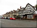
8

Half timbered house on the Gloucester Road (A38)
The half timbered house on the Gloucester Road (A38) opposite the junction with Kellaway Avenue.
Image: © Linda Bailey
Taken: 15 Mar 2006
0.06 miles
9
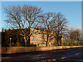
Territorial Army, Horfield
Built in the 1950's, this is the headquarters of the 39 (Skinners) Signal Regiment. Looking north.
Image: © Linda Bailey
Taken: 1 Apr 2006
0.07 miles
10
Junction of Bayswater Road with Gloucester Road, Horfield, Bristol
Image: © Ruth Sharville
Taken: 10 Apr 2011
0.07 miles