IMAGES TAKEN NEAR TO
Alderton Road, BRISTOL, BS7 0UY
Introduction
This page details the photographs taken nearby to Alderton Road, BS7 0UY by members of the Geograph project.
The Geograph project started in 2005 with the aim of publishing, organising and preserving representative images for every square kilometre of Great Britain, Ireland and the Isle of Man.

There are currently over 7.5m images from over14,400 individuals and you can help contribute to the project by visiting https://www.geograph.org.uk
Image Map (Loading...)


Getting Data...Please wait
Leaflet Map data © OpenStreetMap
Images are licensed for reuse under creativecommons.org/licenses/by-sa/2.0
Notes
- Clicking on the map will re-center to the selected point.
- The higher the marker number, the further away the image location is from the centre of the postcode.
Image Listing (54 Images Found)
Images are licensed for reuse under creativecommons.org/licenses/by-sa/2.0
Image
Details
Distance
1
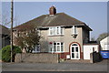
#26 Monk's Park Avenue
There is an OS benchmark Image on the side of the house between the garage door and the house front door
Image: © Roger Templeman
Taken: 24 Mar 2012
0.09 miles
2
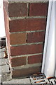
Benchmark on #26 Monk's Park Avenue
Ordnance Survey cut mark benchmark described on the Bench Mark Database at http://www.bench-marks.org.uk/bm42178
Image: © Roger Templeman
Taken: 24 Mar 2012
0.09 miles
3
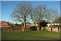
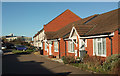
Trees, recreation ground, Horfield
Ticked away in the northwest corner of the recreation ground surrounding Horfield Leisure Centre. Behind the housing on Inkerman Close on the left is Southmead Hospital. On the right are semis on Grittleton Road.
Image: © Derek Harper
Taken: 7 Feb 2018
0.09 miles
4
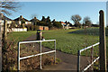
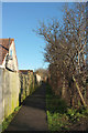
Marg's Way, Horfield
The name given on at least one map to this path around the northern edge of the recreation ground surrounding Horfield Leisure Centre. As in Image], the semis are on Grittleton Road.
Image: © Derek Harper
Taken: 7 Feb 2018
0.11 miles
5
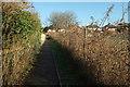
Path, Horfield
Further along the path shown in Image], with houses ahead on Grittleton Road.
Image: © Derek Harper
Taken: 7 Feb 2018
0.11 miles
6
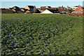
Recreation ground, Horfield
A sprinkling of snow on the northwest corner of the recreation ground surrounding Horfield Leisure Centre. Behind the housing on Inkerman Close is Southmead Hospital.
Image: © Derek Harper
Taken: 7 Feb 2018
0.12 miles
7
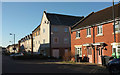
Inkerman Close, Horfield
Looking left from the stretch of the close shown in Image
Image: © Derek Harper
Taken: 7 Feb 2018
0.12 miles
8
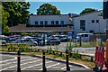
Bristol : Southmead Hospital
Looking towards a car park and Concorde House.
Image: © Lewis Clarke
Taken: 10 Aug 2022
0.12 miles
9
Inkerman Close, Horfield
In the background is Southmead Hospital.
Image: © Derek Harper
Taken: 7 Feb 2018
0.14 miles
10
Path, Horfield
Continuing the line of Bythesea Road around the western edge of the recreation ground surrounding Horfield Leisure Centre.
Image: © Derek Harper
Taken: 7 Feb 2018
0.16 miles