IMAGES TAKEN NEAR TO
Kenmore Crescent, BRISTOL, BS7 0TR
Introduction
This page details the photographs taken nearby to Kenmore Crescent, BS7 0TR by members of the Geograph project.
The Geograph project started in 2005 with the aim of publishing, organising and preserving representative images for every square kilometre of Great Britain, Ireland and the Isle of Man.

There are currently over 7.5m images from over14,400 individuals and you can help contribute to the project by visiting https://www.geograph.org.uk
Image Map (Loading...)


Getting Data...Please wait
Leaflet Map data © OpenStreetMap
Images are licensed for reuse under creativecommons.org/licenses/by-sa/2.0
Notes
- Clicking on the map will re-center to the selected point.
- The higher the marker number, the further away the image location is from the centre of the postcode.
Image Listing (29 Images Found)
Images are licensed for reuse under creativecommons.org/licenses/by-sa/2.0
Image
Details
Distance
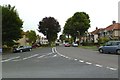
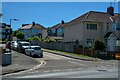
2
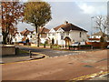
Kenmore Crescent, Filton
Viewed across Braemar Avenue.
Image: © Jaggery
Taken: 6 Nov 2010
0.05 miles
3
Braemar Crescent, Filton
Houses on Braemar Crescent, viewed across Braemar Avenue from the corner of Rannoch Road.
Image: © Jaggery
Taken: 6 Nov 2010
0.10 miles
4
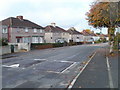
Braemar Avenue west of Rannoch Road, Filton
The view from near the corner of Rannoch Road, looking past speed bumps towards houses on the south side of Braemar Avenue.
Image: © Jaggery
Taken: 6 Nov 2010
0.11 miles
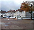
6
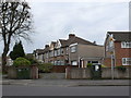
Houses on Dunkeld Avenue
This row of thirties semi detached pebble dashed houses is on the bottom end of Dunkeld Avenue at its junction with Southmead Road the B4056. Dunkeld Ave curves to the left after these houses and runs parallel to Southmead Road, the road in the foreground.
Image: © Nigel Mykura
Taken: 23 Feb 2013
0.13 miles
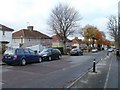
7
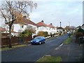
Lomond Road, Filton
Houses viewed from the corner of Braemar Avenue.
A red helicopter, just about visible above the third pair of semis, was noisily disturbing an otherwise quiet Saturday morning in late autumn.
Image: © Jaggery
Taken: 6 Nov 2010
0.14 miles
8
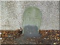
Old Boundary Marker by Kenmore Grove, Bristol
Parish Boundary Marker by the UC road, in parish of Bristol (City of Bristol District), Kenmore Grove, next to the junction with the B4056, Southmead Road, against garden wall.
Inscription reads:-
C B
----
1904
Surveyed
Milestone Society National ID: GL_BSFIL01pb
Image: © Milestone Society
Taken: Unknown
0.15 miles
9
Bristol : Seagry Close
Seagry Close off Southmead Road.
Image: © Lewis Clarke
Taken: 10 Aug 2022
0.15 miles
10
Braemar Avenue, Filton
Houses on the south side of Braemar Avenue. Apparently similar trees are in different stages of autumn leaf fall.
Image: © Jaggery
Taken: 6 Nov 2010
0.16 miles