IMAGES TAKEN NEAR TO
Chantry Close, BRISTOL, BS48 4FN
Introduction
This page details the photographs taken nearby to Chantry Close, BS48 4FN by members of the Geograph project.
The Geograph project started in 2005 with the aim of publishing, organising and preserving representative images for every square kilometre of Great Britain, Ireland and the Isle of Man.

There are currently over 7.5m images from over14,400 individuals and you can help contribute to the project by visiting https://www.geograph.org.uk
Image Map (Loading...)


Getting Data...Please wait
Leaflet Map data © OpenStreetMap
Images are licensed for reuse under creativecommons.org/licenses/by-sa/2.0
Notes
- Clicking on the map will re-center to the selected point.
- The higher the marker number, the further away the image location is from the centre of the postcode.
Image Listing (27 Images Found)
Images are licensed for reuse under creativecommons.org/licenses/by-sa/2.0
Image
Details
Distance
1

A hint of an old scandal?
Some creative artistry in a blanked window on North Street. Note the bird silhouettes near the nest boxes under the eaves.
Image: © Neil Owen
Taken: 29 Sep 2021
0.16 miles
2

North Street
Heading towards Nailsea town centre.
Image: © Ruth Riddle
Taken: 10 Jul 2012
0.16 miles
3
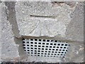
Ordnance Survey Cut Mark
This OS Cut Mark can be found on the front of No19 Union Street. It marks a point 21.9243m above mean sea level.
Image: © Adrian Dust
Taken: 18 Jul 2013
0.16 miles
4

Nailsea Little Theatre
A small stage in Nailsea's west end, in a former Ebenezer Methodist church of 1856. The theatre club was founded in 1965 and extended the old church in 1996.
Image: © Neil Owen
Taken: 29 Sep 2021
0.17 miles
5
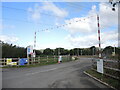
The way into Watery Lane
What was a quiet and inconspicuous lane near Nailsea has been breached by some heavy industry. A massive project to link Bridgwater with Seabank station near Avonmouth is to connect them with underground power cables. The project is, locally, driving a 10.5km line through the area up to Portishead. Overall the new power lines will connect up to new and renewable electricity sources, as well as the Hinckley C nuclear power station currently under construction.
Soon the erection of the new 'T' pylons will begin across the landscape to replace the old versions. The scheme is expected to be completed in 2025.
Image: © Neil Owen
Taken: 29 Sep 2021
0.18 miles
6
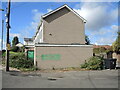
Blocked toilet block
A grey brick toilet block opposite the pub is firmly closed, and has been so for many years. In years gone by this was a village green, complete with a lock-up, stocks and whipping post.
Image: © Neil Owen
Taken: 29 Sep 2021
0.19 miles
7

The Moorend Spout
The pub claims to be Nailsea's oldest still serving. It started life as the Butcher's Arms.
Image: © Neil Owen
Taken: 29 Sep 2021
0.19 miles
8
Watery Lane is cut off
The old lane is now isolated and divided by the construction of an access road to the groundworks beyond. New electricity cables are being driven across Somerset, mainly underground.
Watery Lane has been largely made redundant after Hanham Way was built for the housing estate that has sprung up here. The latter lies parallel and a very short distance from it.
Image: © Neil Owen
Taken: 29 Sep 2021
0.19 miles

10
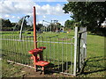
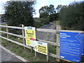
Metal stile to the play park
An unusual and particularly modern stile to aid access to the playground.
Image: © Neil Owen
Taken: 29 Sep 2021
0.20 miles