IMAGES TAKEN NEAR TO
Ridings Wood Way, BS48 3ER
Introduction
This page details the photographs taken nearby to Ridings Wood Way, BS48 3ER by members of the Geograph project.
The Geograph project started in 2005 with the aim of publishing, organising and preserving representative images for every square kilometre of Great Britain, Ireland and the Isle of Man.

There are currently over 7.5m images from over14,400 individuals and you can help contribute to the project by visiting https://www.geograph.org.uk
Image Map
Images are licensed for reuse under creativecommons.org/licenses/by-sa/2.0
Notes
- Clicking on the map will re-center to the selected point.
- The higher the marker number, the further away the image location is from the centre of the postcode.
Image Listing (16 Images Found)
Images are licensed for reuse under creativecommons.org/licenses/by-sa/2.0
Image
Details
Distance
1
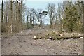
Timber clearance
Bowmans Wood, Oatley Park: development of the large, former Barrow Hospital site (1938-2006) continues with additional housing and soft landscaping.
Image: © Anthony O'Neil
Taken: 9 Mar 2021
0.09 miles
2
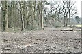
Ridings Wood
Sections being cleared for further house building and associated works.
Image: © Anthony O'Neil
Taken: 9 Mar 2021
0.10 miles
3
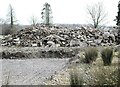
Demolition rubble
Winstone Road, Oatley Park (former hospital site)
Image: © Anthony O'Neil
Taken: 9 Mar 2021
0.13 miles
4
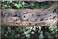
'Insect apartments'
Fallen, rotting timber provides ample accommodation for a host of insects
Image: © Anthony O'Neil
Taken: 9 Mar 2021
0.16 miles
5
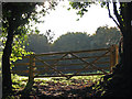
Autumn light
I thought this gate looked rather splendid in the Autumn sunlight, so I took a photo.
Image: © MD
Taken: 12 Oct 2008
0.16 miles
7
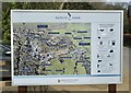
Development Map
Illustrating the extensive housing and landscaping work under way at the former Barrow Hospital site. The Park is named for Bristol's leading architect - Sir George Oatley - who designed the original hospital buildings and, more famously, the Wills Building at Bristol University.
Image: © Anthony O'Neil
Taken: 9 Mar 2021
0.18 miles
8
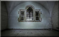
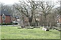
Mortuary chapel
Mortuary chapel, part of the now demolished Barrow Gurney psychiatric hospital
Image: © Noel Jenkins
Taken: 12 Sep 2009
0.19 miles
9
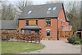
House at The Fillies
Winstone Road, Oatley Park
Image: © Anthony O'Neil
Taken: 9 Mar 2021
0.19 miles
10
Play area
Oatley Park: site of the former Barrow Mental Hospital (now demolished).
Image: © Anthony O'Neil
Taken: 9 Mar 2021
0.19 miles