IMAGES TAKEN NEAR TO
Eastway Square, BRISTOL, BS48 2NL
Introduction
This page details the photographs taken nearby to Eastway Square, BS48 2NL by members of the Geograph project.
The Geograph project started in 2005 with the aim of publishing, organising and preserving representative images for every square kilometre of Great Britain, Ireland and the Isle of Man.

There are currently over 7.5m images from over14,400 individuals and you can help contribute to the project by visiting https://www.geograph.org.uk
Image Map
Images are licensed for reuse under creativecommons.org/licenses/by-sa/2.0
Notes
- Clicking on the map will re-center to the selected point.
- The higher the marker number, the further away the image location is from the centre of the postcode.
Image Listing (84 Images Found)
Images are licensed for reuse under creativecommons.org/licenses/by-sa/2.0
Image
Details
Distance
1
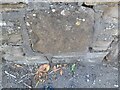
Ordnance Survey Cut Mark
This OS cut mark can be found on the wall of No20 Clevedon Road. It marked a point 24.613m above mean sea level.
Image: © Adrian Dust
Taken: 5 Aug 2022
0.06 miles
2
Southfield Church, Nailsea
Originally built in 1960 and both extended and updated since Southfield is a very active evangelical Christian Church.
Image: © Steve Barnes
Taken: 11 Aug 2009
0.12 miles
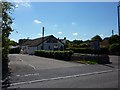
3
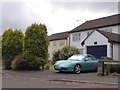
Heathfield Road, Nailsea
Residential road with bungalows
Image: © David Smith
Taken: 26 Jul 2016
0.12 miles
4
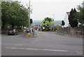
Southern end of Clevedon Road, Nailsea
The B3130 Clevedon Road is ahead and the B3130 Stock Way North is on the right.
Stock Way North to the left of the junction is unclassified.
Image: © Jaggery
Taken: 8 Jun 2016
0.13 miles
5
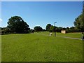
Future Field Of Hope Nailsea
This green walkway near Nailsea Fire Station has been designated as a Marie Curie "Field of Hope" this was taken before planting started.
Image: © Steve Barnes
Taken: 11 Aug 2009
0.14 miles
6
Houses in Chapel Close, Nailsea
Residential road which takes its name from the nearby URC chapel; the car numberplate has been blurred for privacy
Image: © David Smith
Taken: 26 Jul 2016
0.14 miles
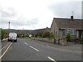
7
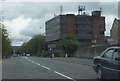
Stock Way North
The road passing a rather unattractive and utilitarian building.
Image: © Ruth Riddle
Taken: 10 Jul 2012
0.15 miles
8
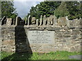
The Somerset Bard lies here
Adge Cutler wrote and sang about much of the Somerset and surrounding villages as leader of the Wurzels. Following his death in a car crash in 1974, he is remembered here in Nailsea. The band recorded their first album in a live performance at the town's Royal Oak pub.
Image: © Neil Owen
Taken: 29 Sep 2021
0.15 miles
9
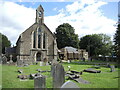
Nailsea's spiritual home
Christ Church was designed in the Commissioners' tradition, Early English style by Scott and Moffat in 1843. A modern extension was added in the twentieth century. In the grounds is the final resting place of Adge Cutler, the much-loved band-leader of the Wurzels. See Image
Image: © Neil Owen
Taken: 29 Sep 2021
0.15 miles
10
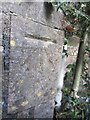
Ordnance Survey Cut Mark
This OS Cut Mark can be found on the East face of the porch of Christ Church. It marks a point 29.8826m above mean sea level.
Image: © Adrian Dust
Taken: 18 Jul 2013
0.15 miles