IMAGES TAKEN NEAR TO
Orchard Close, BRISTOL, BS48 1UD
Introduction
This page details the photographs taken nearby to Orchard Close, BS48 1UD by members of the Geograph project.
The Geograph project started in 2005 with the aim of publishing, organising and preserving representative images for every square kilometre of Great Britain, Ireland and the Isle of Man.

There are currently over 7.5m images from over14,400 individuals and you can help contribute to the project by visiting https://www.geograph.org.uk
Image Map
Images are licensed for reuse under creativecommons.org/licenses/by-sa/2.0
Notes
- Clicking on the map will re-center to the selected point.
- The higher the marker number, the further away the image location is from the centre of the postcode.
Image Listing (62 Images Found)
Images are licensed for reuse under creativecommons.org/licenses/by-sa/2.0
Image
Details
Distance
1
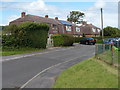
Orchard Close, Flax Bourton
Houses in a cul-de-sac on the east side of Station Road.
Image: © Jaggery
Taken: 13 Jul 2012
0.03 miles
2
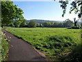
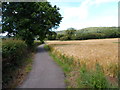
Field, Flax Bourton
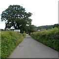
A tarmac footpath provides a safe alternative to walking along Station Road, which runs parallel to the left. On the right is Image, which has lost a good deal of its height in just over four years.
Image: © Derek Harper
Taken: 23 May 2010
0.03 miles
3
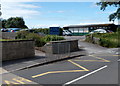
Flax Bourton Church of England Primary School
Viewed from Station Road.
Image: © Jaggery
Taken: 13 Jul 2012
0.03 miles
4
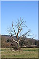
Bare Tree
On the outskirts of Flax Bourton
Image: © Adrian and Janet Quantock
Taken: 25 Feb 2006
0.04 miles
5
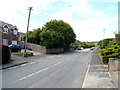
Station Road, Flax Bourton
Looking north from the Main Road end. For more than a century, the village had a railway station.
The first one opened in 1860. It was replaced by a larger station in 1893.
Passenger services in this area ceased in December 1963.
Image: © Jaggery
Taken: 13 Jul 2012
0.05 miles
6
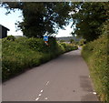
Narrow part of Station Road, Flax Bourton
The road here is not wide enough for pavements, but there is a path http://www.geograph.org.uk/photo/3715677 parallel with the road, behind the hedge on the right.
Image: © Jaggery
Taken: 13 Jul 2012
0.05 miles
7
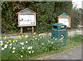
Parish notice boards
A pair of notice boards, similar to a couple opposite the church of St Michael and All Angels. Presumably the notices are copies.
Image: © Neil Owen
Taken: 24 Mar 2014
0.06 miles
8
Path alongside Station Road, Flax Bourton
The hedge separates the path from this http://www.geograph.org.uk/photo/3715674 narrow part of Station Road.
Image: © Jaggery
Taken: 13 Jul 2012
0.06 miles
9
Northern boundary of Flax Bourton
Viewed along Station Road. Flax Bourton is a village in the unitary authority of North Somerset.
Image: © Jaggery
Taken: 13 Jul 2012
0.06 miles
10
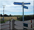
Cycle route signpost, Station Road, Flax Bourton
The 4-armed signpost is near a railway bridge.
Image: © Jaggery
Taken: 13 Jul 2012
0.09 miles